National Geographic October 2014

The Next Green Revolution, by Tim Folger, photographs by Craig Cutler

This installation of the “Future of Food” series focuses on technological improvements in food production, including genetic modification.  Folger starts out talking about the original green revolution.  Fears that millions of people in Asia would die of famine led to selective breeding of wheat and rice.  This allowed the volume of food to increase faster than the population, which meant that not only did they prevent the famine, but that the nutrition level of most of the people of Asia actually increased.

Now, we may be facing another potential famine and we, in Folger’s words, “need another green revolution.”  And one of the potential tools for this new green revolution is genetic modification.  Rather than using crossbreeding and taking your chances of developing another lenape potato (which had dangerously high levels of the poison solanin), scientists can identify the genes that contain the desirable traits and transfer them directly.   These transfers can be done across species, as well.  One famous example of this cross-species transfer is golden rice, which has a gene isolated from corn.  This gene allows the rice to produce beta carotene.  Beta carotene is the ingredient that the human body uses to produce Vitamin A.  Getting enough beta carotene will not only save vision, it will save lives.  Somewhere in the neighborhood of one to two million people die from Vitamin A deficiency every year.

The Next Green Revolution discusses genetic modification and the ways it could conceivably help the people of Africa and Asia in particular.  Among others, we see cassava that are being bred to be resistant to brown streak virus and rice that is being bred to be able to survive under water (for use in places that are prone to flooding).

As you have likely guessed by my lack of panic, I am not against genetic modification, particularly where plants are concerned. I am not a trained scientist or anything of that nature, but I speak a little of the language of science.  I am trained as a medical librarian and I work as a pharmacy technician.  I can see value in genetic modification.  Humans have been messing with our food forever.  Just look at teosinte, the ancestor of corn.  Over years and years, humans increased the size, sweetness, and nutition of the teosinte kernels until they became something entirely different. And a number of our food has been similarly changed.  Watermelons are far different from their original ancestors, as well.

Most of these were done through selective breeding, which involves a lot of wasted time and resources.  Let’s say that you are breeding for trait A.  Your parent plants are likely to be Aa, where “a” is an undesirable trait.  Half of your child plants, on average, will also be Aa.  One-quarter will be aa, which won’t help at all, since “a” is exactly what you don’t want.  Only one-quarter of the child plants will have the desired genes of AA.  With genetic modification, you can take the A from another cell, replace the a in the original seed with it, and the plant that results will be AA.  This means that plants with the desired trait can be tested for safety and put into use a lot faster than they would be with selective breeding.

When the Snows Fail, by Michelle Nijhuis, photographs by Peter Essick

In When the Snows Fail, Nijhuis discusses the drought in the southwest United States.  We meet the Diener family who run a small family farm.  In addition to the usual crops, almonds, broccoli, tomatoes, and so forth, the Dieners are experimenting with growing prickly pear cactus.  Not only is the fruit of the prickly pear cactus edible, but so are the pads, which are known as nopales in Spanish.

The Dieners live in the Central Valley of California, which is where most of the fruits and nuts sold for food in the United States is grown.  The Central Valley was chosen as a place to grow such high-water-use crops because of the richness of its soil and the moderateness of its temperatures.  There is only one problem.  The Central Valley has a dry climate.  This means that in order to grow all of the asparagus, carrots, grapes, and pistachios, water must be pumped in.  Some is groundwater pumped up from wells, but the rest must be brought in from reservoirs. These reservoirs are filled by melting snows from the mountains the surround the valley.

Thanks to climate change, the winters are becoming milder, which means less water in the mountains.  Less water in the mountains then, of course, translates to less water for the farmers.  This is requiring the farmers to rethink their water use and, in some cases, like Diener, the crops they grow, as well.

Medieval Mountain Hideaway, by Brook Larmer, photographs by Aaron Huey

Medieval Mountain Hideaway is about an area of the nation of Georgia known as Svaneti.  For a long time, the region of Upper Svaneti was isolated from the outside by the mountains that surround it.  However, from the invasion of the Russians in the 19th Century and into the 20th and 21st Centuries, much of the culture of Svaneti is slowly being lost.  Only the very oldest of the Svans, for example, speak Svan fluently.  The youth of Svaneti are engaged in something of a cultural revival, however, learning the old Svans songs and dances and learning to play the old Svan musical instruments.  However, it is likely the much of the language which is not preserved in these songs will be lost.

Prior to the Christianization of Svaneti in the 4th century, the Svans were sun worshipers and some of those traditions, largely dealing with fire, were imported into the Christian holiday observances of the Svan.

Svaneti is facing two new threats to its culture.  The first is emigration.  Jobs are scares in Svaneti, and there were dangers in the area including bandits on the roads (the bandits were vanquished by security forces in 2004).  Thousands of people have left for the lowlands.  The village of Adishi once had 60 families, but the population dwindled to the point where only four families remained.

On top of this, the goverment is attempting to turn Svaneti into a tourist destination.  The capital of Mesti, in particular, has many guest houses, and there are new ski resorts being built in the mountains around the area. The question that remains to be answered is whether tourism will save or destroy Svan culture.

Mister Big, by Tom Mueller, photographs by Mike Hettwer

Mister Big is the tale of the discovery of Spinosaurus, the largest theropod dinosaur yet discovered.  The earliest bones of Spinosaurus were found in Egypt in the early 20th century by Ernst Freiherr Stromer von Reichenbach, a German paleontologist and aristocrat.  Among the bones of the partial skeleton that Strohmer found were vertebrae with tall spines sticking up from them, presumably supporting a sail of some sort.   Stromer gave this new discovery the name Spinosaurus aegypticus.

Stromer found it odd that so many top-level predators were found in the same area as Spinosaurus, but comparatively few herbivorous dinosaurs were found in that area.  The paleontologist who figured the answer to this question was Nizar Ibrahim.

In 2008, Ibrahim was shown some dinosaur bones, one of which was broken, in purplish sandstone.  He bought the bones, despite their condition.  In 2009, he saw a partial Spinosaurus in a museum in Milan, and it was clear that the bone he had bought was broken off of one of the bones of the dinosaur in Milan.

In 2013, he found the fossil hunter who sold him that first piece of Spinosaurus (and who also sold the bones in the Milan museum). Ibrahim has since found more bones that are likely from that individual and perhaps bones from others as well, in that location.

The current belief is that Spinosaurus spent at least part of its time in the water.  This would explain some peculiarities in the anatomy of the Spinosaurus, including the positioning of its back legs, which would be better for paddling than for walking.  Also, this would explain the relative lack of prey — the valley where the Spinosaurus was found was part of a network of rivers that was inhabited by large aquatic animals, including both fish and turtles.

The Nuclear Tourist, by George Johnson, photographs by Gerd Ludwig

Chernobyl, in Ukraine (it is a real challenge for me to get used to not typing the “the” that used to be in front of “Ukraine”), is the site of the worst nuclear disaster in history.  For some unknown reason, on April 26, 1986 the people operating the reactor at Chernobyl decided to do a safety test with a skeleton staff. As it turned out, the plant was not safe. During the test, the reactor overheated and there were two explosions. Most upsetting of all, it took 36 hours for them to start to evacuate the nearby residents.  In June of 1986, work began on enclosing the building in a steel and concrete enclosure known in English as the “sarcophagus.”  The sarcophagus was completed in November 1986.  However, the sarcophagus was not sealed properly, and so beginning in 2006, construction on another enclosure, called the New Safe Confinement, was begun.   In 2011, Chernobyl was opened for business as a tourist attraction.

The Nuclear Tourist is an account of the one tour group’s trip into the Chernobyl area.  We see, in words and pictures, the damage done by the disaster, by time, and by tourist groups and the occasional vandal. I found particularly interesting how relaxed the tourists became about radiation.  At one point, the tour guide actually led the group into a high-radiation area and the tourists used their radiation meters to see how high it would go.

Speaking of radiation, the one thing that I found confusing about The Nuclear Tourist were Johnson’s references to radiation levels. I spent a bit of time checking his math and referring back to other parts of the article.  He also opens with the statistic that five sieverts of radiation will kill you, then says that the rescue workers were exposed to 16 sieverts.  My initial response was, “Wouldn’t that have killed them?”  I’m still working on that one.  From what I’ve seen in other sources, it looks like they did develop acute radiation sickness but didn’t die until several days later.

(originally posted June 2015)

Foreign Languages

I have an at-least-passing familiarity with four foreign languages. They are, in order that I started to learn them: Spanish, German, Mandarin, and Italian. Eventually I want to be proficient in at least Spanish and Mandarin and hope to pick up enough of several other languages, particularly Czech, since I am of Czech ancestry, to get along in the countries where those languages are spoken by the time I travel there.

I think my first impulse to learn a foreign language was probably French. We were visiting my cousin and her daughter (who was just a baby at the time, which means that I was probably around nine or ten) and we went to the pool of her apartment complex. A young woman there was speaking French and I was fascinated.

Then, my sophomore year of high school, I had an opening for an elective and I wanted to take German. My mom strong-armed me into taking Spanish instead. During the rest of my high school experience, I ended up taking three years of Spanish. My senior year I finally had an extra opening and got to take German I in addition to Spanish III. I took to German like the proverbial duck to water and after my mom had a chance to meet the young adults in the German III class (who would have been my classmates, had she allowed me to take German) my mom said that she should have let me take German after all. The kids in my Spanish III class were largely the ones whose parents were forcing them to take a foreign language, but the ones in the German III class were creative, and fun, and seemed more motivated. One went on to become a German professor on the college level.

I have to admit that Spanish has been useful. Being as close to Mexico as we are, we get Mexican nationals who don’t speak English in the store from time to time and I can help them myself, rather than having to track down a Spanish-speaker to help me. I am not good enough at Spanish yet to be approved to speak to pharmacy patients about their medications, but I hope to get that good someday. There won’t be any extra money in it, but it will look good on my resume if I can say that I am that proficient.

My son and I started to learn Italian because, frankly, it was the one language that I could find a lot of resources for. We started to learn Italian in the summer of 2013, and in the summer of 2014, we traveled to Italy. My son was mostly able to say things like “Grazie” and “Buongiorno,” but I got along pretty well. I was able to do basic transactions in Italian, even if we did eventually have to resort to English in a lot of cases.

The reason I am writing about this now is because of my Mandarin studies. I still have a lot to learn, but I’m coming along, and in two upcoming posts — one on a planned trip to China in 2021 and my post on the July 2014 issue of National Geographic, I mention my progress in learning Mandarin. In the National Geographic article, I am nearly certain that I was able to understand the name of one of the chambers, but never once does the writer give us any idea what the Chinese corresponds to in English. I am still wrestling with the name of one of the other chambers. Probably most people won’t even notice, but I know just enough Mandarin to know how much I don’t know yet, and so for me, this was really frustrating.

(originally posted, in a slightly different form, on July 2, 2015)

2015 Vacation Destinations: The Intrepid Sea, Air & Space Museum, New York City

I actually considered having Alex, the family airplane enthusiast, write a guest post for me for this one.  During June, as I was planning our vacation, I saw a reference in something unrelated to the vacation that one of the Concorde passenger planes was in New York City.  “How interesting,” I thought, “New York City is a big place, though.  It might not be anywhere near where we are going to be.”  When I looked it up, I discovered that the Concorde’s home is now The Intrepid Sea, Air & Space Museum (which I will refer to from here on as “The Intrepid Museum”) and that not only do they have a Concorde, they offer special tours of it.  I knew then that Alex and I had to at least visit the museum, even if we weren’t able to do any of the special tours they offered.  As fate would have it, we were allowed to do one of the special tours.  But I’m getting ahead of myself here.

The Intrepid Museum is housed in the Intrepid, a World War II-era aircraft carrier berthed at Pier 86 on the Hudson River.  Four decks of the Intrepid: the hangar deck, the gallery deck, the third deck and the flight deck, are open to the public.  The hangar deck of the Intrepid is pretty typical museum, with exhibits and artifacts around the themes of the museum.  The third deck has been restored and is designed to give you an idea of what life was like for the sailors who were stationed aboard the Intrepid. The flight deck is where we spent most of our time on board.   This is where most of the aircraft on display are located.  The fore part (you can tell that I’m hip with the nautical lingo here) of the deck holds aircraft that are out in the open.  The aft part holds a tent where they restore aircraft, and which is open so that the public can see what they are doing, and the space shuttle pavilion.

The space shuttle pavilion is a permanent structure that holds, you guessed it, a space shuttle.  The space shuttle that is housed at The Intrepid Museum is the very first space shuttle built, the Enterprise.  They used the Enterprise to do tests in the atmosphere, and they intended to add things like engines and bathroom facilities later so that it could go into space.  As fate would have it, when they were building the second shuttle, Columbia, they made changes to the design of the shuttles and NASA decided that it would be too expensive and time-consuming to make those changes to the Enterprise.  As a result, the Enterprise is the only space shuttle that has never gone into space.

There are two exhibits that are not on or in the Intrepid itself.  One is a submarine, the Growler, which dates to the Cold War era and is the only guided missile submarine on public display.  Unfortunately, the lines for the Growler were prohibitively long and so we ended up not being able to get in to see the submarine.

However, we did have the chance to spend quite a bit of time around (and, courtesy of the guided tours offered at The Intrepid Museum, inside) the Concorde.  The Concorde that The Intrepid Museum has in their collection is G-BOAD, a British Airways plane, which is something of a celebrity, as airplanes go.  I’ll try to avoid the infodump, but G-BOAD holds the record for fastest crossing of the Atlantic by a passenger jet going both directions.  G-BOAD (commonly known as Alpha Delta) was also the only Concorde to be painted with the markings of an airline other than either British Airways or Air France.  This airline was Singapore Airlines and G-BOAD had British Airways livery on the starboard (right) side and Singapore Airlines livery on the left (port) side in 1980.  By the time the plane was retired in 2004, both sides had been painted with the then-current British Airways livery.  Our guide was very informative and the tour was well worth the extra $20 per person to me, and I am not the airplane enthusiast in our family.

The Intrepid Museum is largely wheelchair-accessible.  I say “largely,” because neither the Growler nor G-BOAD are wheelchair-accessible.  The only places aboard the ship itself that are not wheelchair-accessible are the Fo’c’s’le and the Combat Information Center.

And if the Intrepid Museum has provided you with enough metal for one day and you are craving some green time, the next pier over, Pier 84, has been converted into a public park.  There is a dog park, a playground, kayaking lessons, PD O’Hurley’s restaurant, and water taxi access all available at Pier 84.

Piers 86 and 84 are on 12th Avenue between 46th and 43rd Streets.

Jimmy Carter Has Cancer

Jimmy Carter is my favorite person who has ever held the office of President of the United States.  Just about everything I have heard about him tells what an awesome person he is.  And he is also the only President I have ever met (and he was a sitting President at the time).  Not that he’d remember the meeting.  We were on another trip to Florida (1979, this time, so I haven’t covered the trip in my My Travel Memories topics yet) and we decided to take a side trip to Plains, Georgia, which is President Carter’s home town.  President Carter was in town at the time and we stood with a crowd of gawkers waiting for him to come out of church, of all things.

President Carter came out and my mom grabbed my hand and pushed it through the crowd, yelling for President Carter to shake my hand, which he did.

And now he has metastatic cancer.  All of our heroes have to die eventually, I guess.  90 years is a good run.  He raised his children to adulthood and saw most of his grandchildren grow up.  But I am still distressed by this news. I can only pray that President Carter and his physicians have the wisdom to make the best possible choices for his care.

National Geographic April 2015

Lincoln, by Adam Goodheart, photographs by Eugene Richards

April 15, 2015 was the sesquicentennial (they use “150th anniversary” in the article, but we have such a nice word for “150th anniversary” that I couldn’t resist) of the assassination of Abraham Lincoln. In recognition (and, of course, anticipation, since the trek had to be done ahead of time so as to make it to print in time for April) of the occasion, Goodheart traced the train that carried Lincoln’s body as it made the journey from Washington, DC to Springfield, Illinois.  There was no continuous rail line between the two, so the body ended up making a two-week journey up through Maryland, then into Pennsylvania, to New York (both the city and the state), then through Ohio and Indiana before arriving in Illinois.  The body the went from Northwest Indiana to Chicago and then down to Springfield.  Lincoln’s body had stayed in Washington, DC from the 15th through the 21st, so by the time the body arrived in Springfield, it was three weeks old and had deteriorated considerably.

We see, through Goodheart’s words, we see the body as it travels through the night along tracks lined with people and at its stops in Philadelphia, Buffalo, New York City, and then on to Springfield, where his remains ended up being moved 14 times during the years after Lincoln’s death.  Then, they proceeded to reconstruct the tomb — the current structure is from the 1930s.

Most of the tracks that carried Lincoln’s funeral train are long gone.  There are markers along the way showing where the train passed, and some of the tracks were removed recently enough that you can still see the gravel.  I grew up in Chicago, and it is very likely that those tracks still exist, as Chicago is still a major rail hub.  Additionally, the freight lines connecting the suburbs to downtown carry commuter trains today.  In fact, doing some digging, it looks like if you wanted to travel some of the Lincoln funeral train trail yourself, you could take the Metra Heritage Corridor line from Chicago to Joliet.  Metra’s website says that the Lemont and Lockport stations were there when the funeral train went through.

Hubble’s Greatest Hits, by Timothy Ferris

Ferris shares some of the history of the Hubble telescope.  Originally, the astronomers wanted the telescope to be farther out, but instead the telescope ended up being put close enough to be reached by space shuttle.  And it turned out to be fortunate that it was put so close in.  Problems plagued the early days of the telescope and if it had been unreachable, it would have been a waste of billions of dollars.  Since it was put in closer orbit, however, astronauts were able to bring replacement parts and fix the telescope, which has been sending amazing pictures of deep space for 25 years as of April 24, 2015.

The photos which accompany the article are actually colorized composites.  The one at #9, for example, of the Crab Nebula, is a composite of four images.  The most complex photograph, and the one that captured my attention best, is the image at #2, which is created from 32 images of the Carina Nebula.  It looks almost like one of the later works of JMW  Turner.

How Coal Fuels India’s Insurgency, by Anthony Loyd, photographs by Lynsey Addario

How Coal Fuels India’s Insurgency is about the Naxalites, a Maoist group that is causing problems for the government of India.  Loyd jumps right into the violent nature of the conflict by introducing us to a leader who goes by various names, including Prashant, Paramjeet, Gopalji.  This man of many names introduces himself to Loyd as “Manas.”  Manas had just been part of a confrontation that killed six policemen and injured eight more.

The Naxalites, who take their name from a village in West Bengal where the movement began.  However, now all Maoist rebels are known as Naxalites, regardless of their place of origin.

Most of the followers of the Naxalites are the poorest of India’s poor.  They are poor farmers, Dalits, and members of an aboriginal group known as the Adivasi.  There are a number of college students who have found common cause with the Naxalites, as well.  The Naxalites flourish in the undeveloped parts of eastern India, mostly in the states of Chhattisgarh and Jharkhand.  This region, as it happens, is also the center of India’s mineral wealth.  Beneath the lands where the Naxalites and their followers live, work, and fight are bauxite, dolomite, iron, limestone and, above all, coal.  An area where there used to be farmlands and wildlife is now given over to mines, much of which is done in open “strip” mines.  And effectively none of the wealth generated by these mines are being given to the people of the region.  This feeds the resentment and leads to further recruits for the Naxalites.

And so, until the government of India finds a way to reach out to and communicate with the residents of this poverty-stricken area, it is unlikely that the question of the Naxalites will ever be resolved.

The Bug That’s Eating the Woods, by Hillary Rosner, photographs by Peter Essick

The Bug That’s Eating the Woods is about the mountain pine beetle, a tiny bug that has killed pine trees in an area stretching from northern British Columbia down into California and as far east as South Dakota.  In some areas, such as the area around Wolf Creek Pass in Colorado, nearly all of the trees in the region are killed.

Scientists are trying to figure out why the beetle has had such a devastating effect in recent years and at least part of this devastation is laid at the feet of climate change.  The beetle can travel farther during the warmer months because the farther northern reaches are no longer too cold for them.  Additionally, we have significantly cut down on forest fires, which has made it easier for the beetle to spread.  Some areas are experimenting with controlled burns to isolate the beetle, but it is too soon to see if that will do any good.  There is also some hope that climate change may help.  The beetle’s actual source of food comes from two fungi that it carries with them, one of which needs cold weather.  As cold weather ceases to be quite so cold, perhaps that fungus will become less effective and end the life cycle of the beetle.

I was a small child during the Dutch elm disease outbreak of 1950s through 1970s (specifically the 1970s end), and currently live in an area where oak wilt is always a concern.  As a result, I am aware of the maxim of urban forestry that no more than 10% of an area should be one particular species of tree.  I cannot help but think that something like that might not be a bad rule to follow when planning what to do with the areas that the beetle has hit, even though it is not technically urban.  Perhaps the forestry departments of the various governments could look into broadleaf trees that would fill a similar niche ecologically and economically.  Then they could  plant 50% pine trees and 25% each two chosen broadleaf species, or a 68%/16%/16% mix, perhaps.

Trajan’s Amazing Column, by Andrew Curry, photographs by Kenneth Garrett

Trajan’s Column is a monument in Rome which chronicles the defeat of the Dacians by the Romans during the rule of Trajan.  The column is also where Trajan’s ashes were laid to rest after Trajan’s death in 117 AD.  We are certain that at least that second statement is true. Trajan’s Amazing Column lists some of the arguments that historians are using against the idea that the details given on the column are as accurate as has generally been assumed.  Some of the details match up with what archaeologists are discovering, but much of it may be made up to conform with the idea of how the war should have gone.

When my son and I were in Rome in 2014, we discovered Trajan’s Column by accident.  I’m not sure how we managed to miss it standing there being all columnar and monumental, but we did.  It wasn’t until our last day in Rome that we found it.  We had been to the Trevi Fountain and stopped in a carryout pizza place.  Our purchase of pizza was purely in the interest of science, of course.  We had had pizza in Naples and needed another sample so that we could compare the two.

We now had two slices of pizza and no place to eat it.  So we walked back in the general direction of our hotel, figuring that if we didn’t see any place to sit down before we got to the hotel, we could eat the pizza in our room.  After walking for a while, we found some people sitting on the steps of a church.  This looked as good a spot as any to eat, so we sat, too.

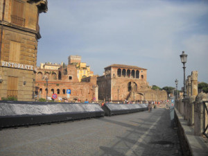
That’s when we noticed the huge monument right there.  Once we finished our pizza we explored the area, taking lots of pictures of the monument and of the ruins of the forums (fora?) of Trajan and Augustus.  I took a panoramic photo of the column.  It wasn’t perfect, since I didn’t have my tripod, but it turned out pretty well.

In the article, Curry mentions tour guides explaining the column.  The signage, at least when we were there, is excellent, though, so one doesn’t need a tour guide.  There is a long sign running alongside the ruins of Trajan’s forum with pictures of the sections and an explanation of what is there (see image).  This sign must be new, since I cannot see it in Google Street View in June 2014, but it was there in July and Google Street View shows it in October, as well.

Sign at Trajan's Column
The interpretive sign at Trajan’s Column in July, 2014.

Argentine Identities, story and photographs by Marco Vernaschi

Vernaschi is an Italian native living in Argentina.  Vernaschi loves his adopted country and feels that the increasing reliance on soybeans as an agricultural industry is counterproductive.  As a result, he and his wife traveled across the country helping small family farmers find new sustainable agricultural projects.  He also took pictures of the residents of the areas that he traveled to.  He stayed away from the “poverty tourism” aspect of photography, where small rural farmers are shown as impoverished.  Instead, he wanted to focus on their culture, including two photographs in which the subjects are wearing ceremonial clothing and one which features a female gaucho. Tags:

Texas State Parks Passes

There are 102 state parks in Texas, stretching from Resaca de la Palma near Brownsville in the south to Palo Duro Canyon south of Amarillo in the north; from Franklin Mountains in El Paso in the west to Sea Rim State Park in Sabine Pass to the east. Wherever in Texas you are, you are likely to be near (for Texas-native values of “near”) a state park. State Parks come in all sizes, as well, from the largest, the 311,000-acre (126,000 hectare) Big Bend Ranch State Park in Marfa to the smallest, the 16.1-acre (6.5 hectares) Old Tunnel State Park in Fredericksburg.

With a Texas State Parks Pass, which in 2015 costs $70, you and your guests can have unlimited visits to the parks of the Texas State Park System. “Guests” generally works out to anyone in the same noncommercial vehicle with the pass holder.  Holders of Texas State Parks Passes also get discounts on purchases in the stores of the parks and also on overnight camping, which can be done in a tent or in a recreational vehicle/RV.

This is not an ad, it’s more of a testimonial. On and off (mostly on) for the last ten years or so, I have been the proud holder of a Texas State Parks Pass. And we take pretty good advantage of our pass. Generally, my “guest” is actually a household member, my son (who has decided that he would like me to call him Alex in blog posts).  Occasionally, Alex and I will bring a friend (or two) with us to a park.

Being that Alex does not have a driver’s license yet, we haven’t wandered too far afield too often.  I am a native Chicagoan.  Where I grew up, anything farther than about 20 minutes away by car is far.  I have adjusted somewhat to the Texans’ idea of “close,” which is something along the lines of three or four hours (before we moved down here, Texans would tell us that San Antonio is close to Mexico, to Houston, and to the Gulf; the closest of these is two and a half hours away0. However, an hour, maybe as much as three for something really important, is about my maximum.  We have made it as far as the San Jacinto Battleground State Historic Site to the east, Mustang Island State Park to the southeast, Garner State Park to the west, and McKinney Falls State Park to the north.  Mostly, though, we stay pretty close to the city.  We visit Government Canyon State Park once or twice a year, and Guadalupe River State Park a little less frequently than that.  We also go to Lost Maples State Natural Area every few years. In another year or so, once Alex has a driver’s license, we will be able to go farther, since we will have two drivers.

I don’t know if we exactly get $70 of activity out of the pass, but we do pretty well.  It is nice to be able to go to a state park on a whim. It is also a nice feeling to know that I am helping support the conservation and preservation work that the Texas Parks and Wildlife Department does.

My Travel Memories: St. Augustine, Florida

St. Augustine, Florida is definitely a place that I visited both before and after 1977.  I went there with my parents in the 1970s (and maybe visited it with my mom, aunt, and uncle in the late 1960s if memory serves) and in 1989 and then, for good measure, I made a return visit with my now-ex-husband in 1992.

In the United States, most people makes a big deal out of the Mayflower, like it is the very beginning of United States history.  I’ve even read a (pretty bad) young adult book in which the protagonist’s love interest is supposedly a descendant of Mayflower immigrants, as if that made him royalty or something along those lines.  As a result, it made a real impression on me when I was told that St. Augustine was the “oldest city” in the United States.  That is, of course, an oversimplification, since St. Augustine is technically the oldest continuously occupied European-established settlement in the United States.  The Native Americans had cities long before the Europeans got here.

St. Augustine got its name because the coast of Florida was first sighted by the settlers of the area on August 28, 1565.  August 28 is the feast day of St. Augustine. If they’d been running a day earlier, the city would be named “Santa Monica,” and if they’d been a day later, I don’t know what they would have named it, since August 29 is the Feast Day of the Martyrdom of St. John the Baptist.  Maybe they just would have gone with “San Juan de Bautista,” or “San Juan” for short.  Spanish settlers did this a lot.  I live in a city that was named for the day that the missionaries met the local Coahuiltecan tribe, the Payaya,

There are, as one would expect, a lot of historical buildings in St. Augustine, though no wooden buildings older than 1702, because the British burned the city in that year.  There is the “Oldest Wooden Schoolhouse,” which is not actually the oldest at all, since the actual oldest schoolhouse in existence in the United States, to our ability to determine, is on Staten Island and is roughly 20 years older than the St. Augustine schoolhouse.

It was always kind of a thrill to walk down the streets of St. Augustine and think about how this is as old as it gets (in terms of permanent European settlements at least) in the United States.  Probably the most interesting building to visit, as far as I am concerned, is the Castillo de San Marcos, which presumably was founded on or around April 25, the Feast Day of St. Mark the Evangelist. The Castillo de San Marcos is older than 1702, since it was built of coquina, a sedimentary rock formed of shells bonded together, and thus it survived the 1702 fire.

Some of the most memorable buildings of St. Augustine are comparatively modern.  In the late 1800s a tycoon by the name of Henry Flagler moved to St. Augustine.  He commissioned a number of elaborate buildings which are there to this day.  Among the buildings he commissioned are the Ponce de Leon Hotel (which is now home to Flagler College), the Alcazar Hotel (now the Lightner Building, containing a museum and the St. Augustine City Hall), and the Memorial Presbyterian Church (which is still a church).

Author’s Note:  I wrote this  and queued it up for June 26, then remembered bits and pieces of another place I’ve been, farther north in Florida than St. Augustine:  Stephen Foster Folk Culture Center State Park in White Springs, Florida.  I don’t really remember much about it, though.  I remember a building with a colonnaded porch (the museum, apparently), trees covered with Spanish moss, and my mom explaining that the correct name of the river is “Suwannee” and not “Swanee.”   That last is how I came to be pretty sure that the park I remember is the one in Florida and not the Stephen C. Foster State Park in Georgia.  The river looks closer to the Florida park than it does to the Georgia one.  I also cannot see any buildings with columns in any photographs of the Georgia park.

(originally posted June 26, 2015)

2015 Vacation Destinations: The Financial District and Federal Hall, New York City

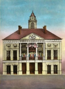
My son is in high school and social studies is not his strongest area generally.  It wasn’t my strongest area either when I was his age, so one of the things I attempt to accomplish on our vacations is to give him “hooks” to hang historical information on. To that end, after we finished the Statue of Liberty/Ellis Island cruise, we went off in search of Federal Hall, the location (but not the building) where George Washington took his oath of office when he was president.  The first governmental offices of the United States government were located there, as well.  I found a public domain image of the original building that was on the site.

The Original Federal Hall
The original Federal Hall. This image is in the public domain and came from the Library of Congress archives.

Along the way, we talked about the financial district and the sorts of things that the firms there do. We passed the Charging Bull statue and discussed how the city put a barricade and an armed guard around the statue to protect it from the Occupy Wall Street protestors.

As we got closer to Federal Hall, I realized that Federal Hall is kitty-corner from the New York Stock Exchange building, so that was convenient.  As important as the NYSE is in our culture, I’m not sure I would have gone out of our way to see it, as we were exhausted by then.  We were able to drag a bit more walking out of ourselves by heading up towards Ground Zero (the directions we got from Google Maps were confusing and didn’t quite lead us to the right place, but we ended up pretty close), and then we headed toward the nearest subway station back to the hotel, which, as it turned out, was City Hall/Brooklyn Bridge.  I got a bit of a second wind when I was seized with a yearning to see if I could find the skylights for the old City Hall station.  We walked around City Hall once (they were doing construction of some sort, so I didn’t even get to see the cement pad that they put over the skylight) and off to the subway station we went.  I also got to see the Brooklyn Bridge, at a distance, for the first time in my life.

When we got back to our hotel, I told my son never to let me walk that far in one day again.  His response? “I tried.”  And he really did.  And we did do more walking that evening, once we recovered a bit.  There’s no point being as close to Times Square as we were in our Midtown hotel without exploring.  By the time we went to bed, we had walked 12.25 miles, which was a record for the nine months since I found the S Health app on my phone (more on that in a future post), and may well have been close to a lifetime record as well.

National Geographic August 2014

Before Stonehenge, by Roff Smith, photographs by Jim Richardson

Before Stonehenge is the cover story, and, like other cover stories, the blurb on the cover doesn’t even begin to, well, cover it. The blurb says, “The First Stonehenge: Britain’s Master Builders” and, well, this article does discuss the Stones of Stenness, which is likely to be the oldest stone circle in Britain. But the article is so much more than just that one monument.

In Before Stonehenge, we see Skara Brae, for example.  Skara Brae is an entire neolithic village on a headland known as the Ness of Brae.  The homes had furniture and built-in storage units that would likely have been a lovely selling point if there were any such thing as a stone-age real estate market.

When you look at Orkney, an archipelago to the north of Scotland, on a map, it seems like it should be cold and inhospitable.  It is roughly parallel with the Gulf of Alaska, after all.  And yet, the average low temperature for Orkney for February (the average coldest month) is 35.1 degrees Fahrenheit/1.7 degrees Celsius.  That’s 15 degrees Fahrenheit warmer than the average low temperature in February in Chicago.  Credit for this mild climate goes to the Gulf Stream.  Thanks to the Gulf Stream, the islands had a bustling agricultural economy that allowed the residents the freedom to express themselves artistically, as well.  So far, more than 650 works of art have been discovered.

And Orkney was not nearly as remote as its location would have you believe.  It was, in the words of Caroline Wickham-Jones of the University of Aberdeen, “an important maritime hub, a place that was on the way to everywhere.”  And the article contains a map that shows the extent of the settlements of Orkney during the Neolithic.  The current estimates are that there were more than 10,000 people living in the Orkney islands during the Neolithic.

Best of all, only around 10% of the Ness has been excavated, which means that there are certainly more treasures to be discovered on the Ness of Brae and, perhaps, all over the Orkney Islands.

Gombe Family Album, by David Quammen, photographs by Anup Shah and Fiona Rogers

On April 3, 2014, Jane Goodall turned 80 years old.  In recognition of the occasion, David Quammen interviewed  Goodall.

Goodall recalls being told that she had done her work  “wrong” in the minds of the establishment in animal behavior.  When Goodall went to Cambridge to get her Ph.D. in ethology, her professors didn’t want to hear about the personalities of the chimpanzees. They wanted her to be able to find patterns in their behaviors.

From here, the conversation moves on to discussions of the personalities, and personal histories, of some of the chimpanzees she got to know at the Gombe Stream Research Center in Tanzania.

The article is illustrated with a photo of Goodall in the 1960s holding hands with a chimpanzee named Figan.  This photo was  taken by Hugo Van Lawick.  There are also beautiful portraits  of some of the chimpanzees she worked with:  Frodo, Samwise, Gaia, Sparrow, Gremlin, Gizmo, and Nasa.

The New Face of Hunger, by Tracie McMillan, photographs by Kitra Cahana, Stephanie Sinclair, and Amy Toensing

The New Face of Hunger, this issue’s installment of the Future of Food series, is based in the United States.  The article focuses on the millions of Americans, most of whom are working full-time, who are facing food insecurity.  You are likely familiar with the term “food insecurity.”  This is the term which, since 2006, has replaced “hunger” in order to reflect the new reality of hunger in the United States.  In past generations, people either had plenty of food or were pretty consistently short on food.  In the current era, however, many people have plenty of calories but are short on nutrition, which can lead these people to become obese.  Additionally, these people cannot aquire  even the high-calorie low-nutrient-dense foods that they have the time and/or money predictably, which leads them to have this new term, rather than calling them “hungry.”

In The New Face of Hunger, we visit food-insecure families in Iowa, Texas, and New York. We talk about the food insecure and food deserts.  Many people live in what is known as a food desert.  A food desert, according to the United States Department of Agriculture, has to meet two criteria:

  1. They qualify as “low-income communities“, based on having: a) a poverty rate of 20 percent or greater, OR b) a median family income at or below 80 percent of the area median family income; AND
  2. They qualify as “low-access communities“, based on the determination that at least 500 persons and/or at least 33% of the census tract’s population live more than one mile from a supermarket or large grocery store (10 miles, in the case of non-metropolitan census tracts).

The article also discusses the role of subsidies in hunger.  The top five most highly subsidized crops between 1995 and 2012, were corn, cotton, wheat, soybeans, and rice.  The four of these that are edible are high-energy (which is the fancy way of saying that they have lots of calories) but are not so full of nutrients.  Fruits and vegetables, to the extent that they are subsidized, are subsidized at a much lower rate, which keeps those crops much more expensive (particularly on a per-calorie basis) than crops such as corn and wheat.  On the other hand, however, the subsidies that do exist help to keep the high-calorie foods that are highly subsidized more affordable to low-income people.  Without those subsidies, perhaps rather than food insecure people, we’d have a much higher rate of the truly undernourished poor in the United States.

While noodling around with the Food Access Research Atlas on the USDA website, I found evidence that apparently the USDA does not consider a Walmart Supercenter to be a supermarket, despite the fact that a Supercenter is about 1/3 groceries.  A new Supercenter opened in San Antonio last year and the area right next to it is shown as being a low-income area more than a mile from a supermarket or large grocery store.  Upon further looking at the map, I think that perhaps that’s just a side effect of the size of the census tract, because I just realized that there is an indisputable “supermarket or large grocery store” just about a mile from that Supercenter, also bordering on that same census tract.  Maybe, since the tract is so large, since the people on the far end are more than a mile from a store, all of them are considered to be in a food desert.

Franz Josef Land: The Meaning of North, by David Quammen, photographs by Cory Richards

In Franz Josef Land: The Meaning of North, Quammen and Richards accompany a scientific expedition to Franz Josef Land, an archipelago in the far north of Russia to determine why the ice is melting, how extensive the melting will be, and what the ecological consequences of the melting will be.  Their group of 40 people include experts and students in a variety of disciplines including but not limited to botany, microbiology, ichthyology, and ornithology.

We meet a number of the people on the expedition including Michael Fay, the botanist, who walked across the forests of Central Africa.  We also meet Enric Sala, whom we will see again in the September, 2014 article on the Southern Line Islands.

One of the things that is emphasized is how heavily armed the guards that accompany the expedition are.  I was wondering if the expedition was facing some kind of danger from humans.  I’m not sure who would be a threat that far north, maybe some kind of insurrectionists would be hanging out there, but it turns out that the guns are to protect them from polar bears.  And the author does have one close call.  Fortunately the situation is resoilved without violence,  There is a  lovely closeup photograph of a polar bear (not taken during that close call but with a remote camera).  The caption states that the remote camera was later chewed up by the polar bear.

And, of course, no conclusions can be made yet about the fate of the ice of Franz Josef Land.  All the scientists can do is collect data, watch trends, and see what conclusions they can draw from those down the line.

The Hidden World of the Great War, by Evan Hadingham, photographs by Jeffrey Gusky

The Hidden World of the Great War is about the reality of the trench warfare of World War I.  The soldiers did not just stand in trenches, they also built extensive tunnels and lived in ancient underground quarries.  These tunnels and quarries were dug into chalk and limestone, both of which are soft enough to carve, and some of the soldiers did just that.  There are, of course, the requisite names carved into the walls, but soldiers also left art behind.  There are portraits and symbols, including a praying soldier and a carving of Marianne, the symbol of the French Revolution.

(originally posted May and June 2015)

2015 Vacation Destinations: Ellis Island, New York/New Jersey

After we finished at the Statue of Liberty, we took the ferry to Ellis Island.  We did a few of the activities in the museum, but I had another goal in mind.  You see, my maternal grandfather and his mother (my great-grandmother, of course) came in through Ellis Island very early in the 20th century.  I was far more interested in sort of getting in touch with their experiences while they were there.  I looked at floors and walls and doors, searching for things that were probably there when my ancestors were.

The Main Building has been restored and looks beautiful. The museum was mostly photographs and interpretive signage and things of that nature and didn’t have much in the way of artifacts.  We spent some time exploring the building and discovered the Great Hall, which I was totally unable to do justice to in photographs.

Then we went outside and my son got some rest while I examined the Wall of Honor.  The Wall of Honor is a series of metal plaques that have immigrants’ names inscribed on them.  The Statue of Liberty – Ellis Island Foundation raised the money to renovate the north side of the island by putting names on the wall in exchange for a donation.  I am not sure if they are still adding names to the wall.  The Foundation’s website seems to indicate that they are, but I thought I saw something at Ellis Island indicating that they are not taking any more names.  If they are, I am very tempted to add my great-grandmother’s name, since she has many more descendants than my grandfather does.

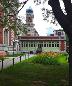
The area behind the Main Building is well worth visiting, if you go to Ellis Island.  The Wall of Honor circles a little bit of greenspace.  There is also a place where one can see some of the foundations of Fort Gibson, which stood on the island before Ellis Island was used for immigration.  You can see the skylines of both Manhattan and Jersey City from the grounds of Ellis Island, as well.  And off tucked by the northeastern corner of the Main Building, there was the prettiest little bed of lilies (see image).

Lillies on the north side of the main building of Ellis Island
A bed of lilies on the northeast side of the main building of Ellis Island.

Overall, I was not terribly impressed by the museum, but I found that my visit to Ellis Island was definitely worth the time it took to explore the island, nonetheless. And maybe someday they will get the money to complete the restoration of the south side of the island, the buildings of which are falling into disrepair.