National Geographic September 2015, Part 1

Tracking Ivory by Bryan Christy photographs by Brent Stirton

Generally, for these posts I read the hard copy and then pull up the Internet version of the issue to refresh my memory while I write the article. In this case, I had to refer back to the issue, because the title at the top of the webpage was How Killing Elephants Finances Terror in Africa, and my first response was, “That’s not a National Geographic article. That’s a term paper.” And, yes, the title of the article in the actual hard copy is Tracking Ivory, which is the name given to the entire section of the website where the article can be found.

The National Geographic Society is starting a Special Investigation Unit and Tracking Ivory is the first article on the work of this unit. Christy was an attorney, but he is now a journalist. In Tracking Ivory, he hires a world-class taxidermist to make fake elephant tusks. These fake tusks look and feel exactly like the real thing and also have a hidden compartment where Christy hid a transmitter. Using this, Christy hoped to be able to track the path that the fake tusks will take.

Curbing poaching of elephants is important for two reasons. The most obvious, and most pressing, is that the population of elephants is dropping quickly — about 30,000 elephants are killed every year. The second reason is that the proceeds from the sales of these tusks is being used to finance terrorism. The Lord’s Resistance Army, the terrorist group headed up by Joseph Kony, is one of the primary traffickers in ivory.

Christy brings his fake tusks into Africa (and is detained by police along the way, which gives him hope that the traffickers will fall for his fake tusks) and gets the tusks to the traffickers. Along the way, we hear the stories of some of Kony’s victims.

At the article’s end, the tusks are in a house in Sudan, likely buried in the yard, because the tusks are in an environment that is cooler than the local air temperature. I have looked to see if Christy has posted any kind of update on their position, but have been unable to find anything.

Point of No Return, by Mark Jenkins, photographs by Cory Richards

Right up front, I’m going to tell you that the photograph on pages 88 and 89 is a spoiler for the ending. If you want to be kept in suspense, I recommend that you take a paperclip and ever-so-carefully paperclip the pages together so that it goes directly from page 87 to page 90.

Point of No Return follows Jenkins and Richards and the rest of their team of climbers as they attempt to be the first to take a GPS reading of the height of Hkakabo Razi in Myanmar, which may be the highest mountain in Southeast Asia. It was long thought to be the highest until another team of climbers reached the top of Gamlang Razi and used GPS to measure that mountain as 19,259 feet, which is higher than the most recent figures on Hkakabo Razi.

Jenkins is one of the last survivors of an adventuring group formed in 1993. The original group was four young men, two of whom are now dead. The fourth has stopped having these types of adventures, so Jenkins was climbing Hkakabo Razi, one of the most challenging mountains in the world, not just for him, but in memory of his late friends.

The climbing team consisted of five people, three men and two women, but ultimately only the three men attempted the final ascent. One of the women was insistent on going, but ultimately she makes what Jenkins describes as “the correct decision” and chooses to send one of the men instead. Unfortunately, we just have Jenkins’s word that it was the correct decision.

Ultimately, the climb is harrowing and I was very happy indeed to be sitting calmly at my sideline job on a balmy 70-degree day in South Texas, rather than attempting that climb myself.

Parks in (and near) San Antonio

So, today one of my co-workers said, “There aren’t any good parks in this part of the city.” Well, one of the things that Alex and I do on our weekends is explore city and county parks (and parks beyond the city and county), so I took that as a challenge.

At first, one of the pharmacists suggested Friedrich Wilderness Park (one of my personal favorites), which is up a ways on Interstate 10.  I then asked what my coworker considered to be “this part of the city,” and she said, “north of downtown.”

I then listed Government Canyon State Park and Hardberger Park and Walker Ranch Park and Denman Estate Park.  The other pharmacist said, “There’s one on Bandera, isn’t there?” This is Schnabel Park.

Finally, before I got too out of control, I said, “I can do this all day, but just one more.  Eisenhower Park, which is straight up Northwest Military until you run out of street.”

I didn’t even get to mention Guadalupe River State Park, or Crownridge Canyon Park or the Cibolo Nature Center (which is in Boerne and the last time we were out there, there was talk about making the other side of City Park Road a park, and they might just have done this by the look of things) or Stone Oak Park (which was not as wooded as Google Maps made it look, so Alex and I promised to come back once the weather was cooler) or any of the probably a dozen other parks I’ve visited in the last couple of years. I even found another new park while I was writing this post — Panther Springs Park.

I really can do this all day, but it’s my bedtime now so I’m going to stop here.  However, since you are not a captive audience and can leave whenever you want, I will be writing up all of these parks (and probably some more that I can’t remember right now) as individual South Texas Destinations posts in the future.

Before I go to bed, however, one more thing. I had two problems with essay questions when I was in school.  One of these was that I have some sort of motor coordination disorder.  I’m not actually handicapped so you’d notice, but I have always had poor both fine and gross motor skills (this may be part of why walking is my major form of exercise — I know I can do it successfully). As a result of this motor coordination problem, writing by hand is very tiring for me.  I’d get tired long before I ran out of ideas on essay questions (I also never knew that other students didn’t have this kind of hand fatigue from writing — I always sort of assumed that the pain and fatigue was part of the test).  The other is that it never occurred to me that the point of essay questions was to just dump whatever you can remember onto the page.  It seemed that they should be written well.  Otherwise it wouldn’t be an essay so much as a bullet-point list.  As a result, if I couldn’t make an idea fit into the flow of what I was writing, I would just leave that idea out, which led me to often only listing part of what I knew.

All of this is in aid of me sticking in an idea that I can’t make flow with the rest of this post. Back about eight years ago or so, San Antonio came out really high on one of those “fattest cities” lists.  One of the websites reporting on it, possibly the originating site, blamed at least part of it on having a very low number of parks per capita. While I was writing this, I found one article, from 2009 (San Antonio was #3 on this list), but I don’t think it’s the one I was thinking of (I swear I remember my ex talking to me about it and we split up before 2009). The number of parks in the 2009 article was 214.  It seems like every street corner has a park these days.  I wonder if some of the parks that I’ve been visiting, and that I will write about, were created after 2009. The Howard W. Peak Greenway System, which are paths that follow the creeks, was approved by voters for the first time in 2000, but I don’t know when the first trails opened.  I think that I may make a note on my posts on city parks what year they were founded, just to see if my perception that many of these parks date from after that checks out.

As to whether these kinds of rankings actually mean anything,  I found this article at PubMed, which I am linking to so that I can save the link to read in the future. Maybe I’ll read it tomorrow, while I’m on my lunch.

My Travel Memories: Assorted Places in Maryland

I can recall four places in Maryland that we visited during our 1979 vacation. I also seem to recall spending the night in a Holiday Inn in Baltimore at some point before our 1988 return to Baltimore (more on that later), so this may have been the visit when we did that.

The four places I recall more-or-less clearly were the National Shrine of Elizabeth Ann Seton, the Barbara Fritchie House, the Antietam battlefield, and a cave.  There is no indication in the photo album which cave we visited.  It made an impression on me because the guy who gave us our tour looked to be only a couple of years older than I was, and he was *adorable.*

Elizabeth Seton was the first United-States-born saint (even though, technically, the United States didn’t exist at the time of her birth — she was born in 1774). When Seton’s husband was dying of tuberculosis, his doctor sent them to Italy, hoping the change of environment would be good for his health. It wasn’t, and he died. Seton converted to Roman Catholicism on the trip. As a widow, Seton needed a source of income, so upon her return home to New York City, she started a girls’ school, but this school failed because of anti-Catholic bias in New York.

Maryland was founded as a settlement for Roman Catholics.  It is, after all, right there in the name.  Seton was invited to move to Maryland and start a new school there, which she did.  This was St. Joseph’s Academy and Free School, the first Roman Catholic school in the United States. These days, nearly all Roman Catholic churches have schools associated with them.  This tradition started with Seton and St. Joseph’s Academy. Seton was beatified in 1963 and canonized in 1975.

The campus of the shrine is beautiful, though I don’t know if we spent much time in the basilica on the site or not.

We also went to the Barbara Fritchie House and Museum in Frederick Maryland.  Fritchie is the subject of the Whittier poem about an elderly lady who interrupted the march of the Confederates by waving a Union flag at them during the Civil War. It is likely that this event never happened. Records show that Fritchie was sick in bed when the Confederates marched through Frederick and that the Confederates never marched down her street.  And to top it all off, the house that Fritchie actually lived in was destroyed during a storm and the museum is in a replica built in 1927.  It’s a lovely poem, however. Fritchie was also personal friends with Francis Scott Key, who wrote the poem which eventually became the national anthem of the United States.  I seem to recall that the guest room was made up as if Key were staying there, though I may be remembering a different house entirely, or maybe I dreamed it.  I have very vivid dreams.

We visited the Antietam battlefield because one of the tour guides, I think it was, or maybe it was someone who worked in one of the restaurants in Gettysburg, told us that Gettysburg was too touristy and that he always recommended that people go to Antietam instead. Now I’m wracking my brain.  The place, which I’m now reasonably certain was a restaurant, had something to do with snipers.  So after looking around, perhaps it was the Farnsworth House, which is a Civil War themed restaurant and the house was apparently a post for snipers. So that’s a good candidate.  I wonder what would happen if I were to call them up and ask about a man in period soldier’s costume who told us to visit Antietam. . .

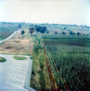
He was right, though. Antietam, site of the battle known both as “Antietam” and as “the Battle of Sharpsburg” was relatively untrammeled by tourists (see the empty parking lot in the photo below).  The Battle of Antietam, which took place on September 17, 1862, was the first battle of the Civil War to take place in Union territory, and was the single bloodiest day of the war.  The Union more or less won this battle, as they only lost 16% of their men, versus 27% for the Confederacy.  “Only” 16%.  Eesh.  It was also “only” the fifth worst actual battle of the war.

Antietam Battlefield, 1979
Antietam Battlefield in 1979 from the 1895 Observation Tower.

It was very educational and the area where the battle took place was lovely, and is apparently becoming even nicer. The National Park Service is trying to restore the areas that were wooded at the time of the battle.  Every fall and spring since 1995, they have had volunteers come in and plant over 18,000 trees in hopes of restoring the appearance of the area to how it looked in 1862.  In the process, they hope to increase the ecological value of the land.

National Geographic December 2013, Part 3

The Unexpected Walrus, by Jeremy Berlin, photographs by Paul McNicklen

I am unclear on what is unexpected here.  The Unexpected Walrus is a brief sort of biological sketch of the species and the effect that human activity can have on their numbers.  Walruses’ whiskers are apparently very sensitive and they can hoover up food from the ocean floor like no one’s business.

It’s an ill wind that blows no one any good, however, and apparently global warming is exposing more clams, which are a main source of food, than the walruses would normally have been able to get to.  So as difficult as humans have made the life of the walrus, at least the walrus is finding food more plentiful than in the past.

The Weed that Won the West, by George Johnson, photographs by Diane Cook and Len Jenshel

The Weed that Won the West is a quick read about the history and lifecycle of the tumbleweed, more formally known as “Russian thistle” and also of Johnson’s history with said plant. Johnson, who has been fighting tumbleweeds ever since he and his wife bought a horse ranch in New Mexico, compares the tumbleweed to a The Outer Limits episode, “Cry of Silence,” in which a young couple are menaced by sentient tumbleweeds.

Turns out tumbleweeds don’t actually need sentience to be menacing, because they are pretty much optimized* to reproduce.  As tumbleweeds tumble along, they are shedding seeds.  Then the seeds can lie dormant for years, but can germinate in as little as 36 minutes. The plant also has a taproot which can reach a depth of six feet.  This means that you can pull all of the plants out of the ground and it can still grow a new plant from the taproot.  And even after you think you’ve gotten all of the plants off of your property, there still can be seeds in the dirt waiting to sprout. The only defense I have been able to find is that the seeds cannot germinate in packed dirt, which is kind of impractical.  In order to use this defense, every square foot of land in the area must somehow be packed down perfectly and remain packed down until all of the seeds have lost their ability to germinate.

Before I moved to San Antonio, I imagined that it looked like an old west city, like Dodge City in the old movies, with tumbleweeds tumbling down the streets.  Thank goodness it isn’t. I have enough fun trying to keep on top of the runners that my live oak trees put out.  I don’t want to have to wrestle with tumbleweeds on top of that.

*You have no idea how much time it took me to find the word “optimized” — I almost went with “maximized,” because it was pretty close.  I also researched “tribbles,” even though I’m not terribly gung-ho on Star Trek (I’m more of a Babylon 5 girl, myself) in hopes that I’d stumble across the right word.  Finally I stuck “maximized for reproduction” into Google and the second hit was titled, “Optimal Reproduction Tactics,” and the rest was history.

South Texas Destinations: The Alamo, San Antonio

Nearly everyone in the United States has some awareness of the Alamo, even if it’s just our fifth-grade teacher saying “something something ‘Remember the Alamo’ something something” in social studies.  Or, “Hey! Isn’t that the movie with John Wayne?” There’s a lot of that going around.

The Alamo, more properly called “Mission de San Antonio de Valero,” was one of the five missions in San Antonio that were founded by Franciscan missionaries from Spain.  The word “Alamo” means “cottonwood,” and no one is sure how the mission got this nickname.

The original Alamo mission was in or near what is now San Pedro Springs Park (writeup to follow later, but for now, the header image on this blog is from the park). The mission moved several times over the years before finally settling in its current location near the San Antonio River.

What we see as the Alamo today is by no means the entire mission.  The mission started not too far behind the current buildings (which were the church and the convento, where the monks lived) and stretched out in front of the mission, across Alamo Street. As I write this, you can see the foundation of the original walls on the other side of Alamo Street. There are discussions of somehow rebuilding the complex, but with buildings that are also historic landmarks on the other side of the street, I find that impracticable.

You may find it odd that the Alamo grounds didn’t to all the way to the river.  That is because the missionaries set up an alternative sort of water delivery system called “acequias.” The acequia system in San Antonio consisted of seven acequias, one for each mission, one for San Fernando de Bexar, the original village that eventually became San Antonio, and another that started out as a flood control measure in the late 19th century.

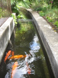
Alamo acequia with koi
The acequia behind the Alamo, which was, at least in 2014 when I took this picture, home to a school of koi.

As an aside, if you know your Catholic saints, I am sure you notice that there is no St. Antonio of Valero or St. Ferdinand of Bexar.  As I point out in my post on St. Augustine, Spaniards named places after the saint’s day that they were first sighted/visited/settled.  San Antonio de Valero was founded on the day of St. Anthony of Padua.  The “Valero” comes from the title of the Viceroy of New Spain at the time, Baltasar de Zúñiga y Guzmán, duque de Arión y marqués de Valero (title copied and pasted from the Wikipedia article, because I’ve got places to go today and didn’t have time to painstakingly transcribe all of that). I would assume that San Fernando de Bexar was founded on May 30, which is St. Fernando’s feast day, and took a different part of Baltasar’s title.  Baltasar was the second son of the Duke of Béjar, Spain.   The “j” turned into an “x” as a result of Mexican influence.

The Alamo was an active church until the Spaniards deconsecrated (which is different from desecration) it in 1793.  Then when the Texians wanted their independence from Mexico, the famous battle was held at the site, which was pretty much a ruin by then, in March of 1836.  All of the adult male Texians died during the battle, though some women and children survived. One of the primary sources that historians have traditionally used are the reminiscences of Enrique Esparza, who was present for the battle, though he was either six or eight years old at the time.

This is where the “Remember the Alamo” part comes in.  The Battle of the Alamo was such a resounding defeat for the Texians that they went on to win the final battle of the Texas Revolution, the Battle of San Jacinto (“Jacinto” is pronounced, “ja-cin-toe,” not “ha-ceen-to”) in 18 minutes.

Over the intervening years, the locals scavenged the site for building stone, leaving just the church and part of the convento standing.  Texas became a state of the United States on December 29, 1845, and the United States Army rented the church, such as it was, beginning in 1846 (my fingers keep wanting to type “19” instead of “18” for the years.  This is probably a side-effect of typing birth years nearly all day at work).

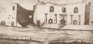
The Alamo, 1840, by Moore
The Alamo in 1840, by Francis Moore, Jr. Note that the top of the front of the building is flat-ish. The United States Army added that curved parapet when they moved in 1850 or so. This image is in the public domain.

San Antonio seceded from the Union along with the rest of Texas on February 1, 1861, so that was pretty much it for the presence of the United States Army at that point.  They moved out, then back in after the Civil War.  When Fort Sam Houston was founded in 1876, the Army left the Alamo for good.

The Alamo was used for other purposes for several decades, including as a general store.  The Alamo now belongs to the State of Texas, which appointed the Daughters of the Republic of Texas as caretakers.  In 2011, care of the Alamo was transferred from the Daughters of the Republic of Texas to the Texas General Land Office.

The Alamo has another, more odd, bit of history. Moving mature trees is a thing around here.  I don’t think I’d ever heard of that before moving to Texas.  At least in the area where I grew up, if you want a tree in a location, you plant a sapling and wait, but here in San Antonio there are actual companies that exist just to move trees. The first mature tree successfully transplanted in the area is in the courtyard of the Alamo.  They estimate that the tree is around 140 years old and it has been in its current location since it was put there by Walter Whall in 1912.

As you probably know by now, I’m a Chicago girl, and when first found out that I was moving down here, a coworker told me that she had expected the Alamo to be out in the desert (probably thanks to our friend John Wayne), but that it was right downtown.  My frame of reference for “downtown” is tall buildings and big business.  I was picturing it somewhere like Daley Plaza in Chicago. I found the reality to be very different.  The tall-ish buildings part of downtown is a good quarter-mile to half-mile away from the Alamo. The area where the Alamo sits is mostly hotels, actually.  There’s the Menger (five stories), behind it is the Crockett (six stories), and to the north is the Emily Morgan Hotel (13 stories), so if you’re imagining a concrete canyon, don’t.

You will notice that I do not have any photographs of the inside of the Alamo.  This is because the Alamo has a no-photography policy.  There are photographs of the interior available online, if you want to go looking for them, but I have never felt comfortable trying to take pictures there myself.  The Alamo is handicap accessible.  I thought that the exit door had stairs, but after looking at photographs (of the outside), I see that I was mistaken.

National Geographic December 2013, Part 2

First Skiers, by Mark Jenkins, photographs by Jonas Bendiksen

The question of which people were was the first to ski is a complicated one. The invention of skiing is largely dated by petroglyphs, which are carvings in rock. There are ancient petroglyphs in both Norway and in China, possibly giving both the claim to having been the first to ski. To make matters more complicated, the oldest ski ever found is a fragment that has been dated using carbon dating, as 8,000 years old. It was found neither in Norway nor in China, but in Russia.

Jenkins takes the tack that the people in China, who are not ethnic Han, but Tuvan, who come from Siberia. Jenkins takes us to China to see these people, the Altay, at work. They do ski to this very day, using one ski, the bottom of which is covered in horse fur, and one pole. The horse fur is oriented so that the nap raises up when the skier is going uphill and prevents the skier from sliding downhill. When oriented in a downhill direction the nap lies flat and allows the skier to slide.

Jenkins also watches the Altay people show him the traditional Altay method of hunting elk. Elk-hunting is forbidden in China, so Jenkins’s hosts merely show him how to track and rope the elk and no elk are actually harmed in the process.

Virtually Immortal, by George Johnson

Virtually Immortal is about the projects of a group called CyArk from Oakland, California, to document as many historic structures as possible. They used computers to make virtual copies of many landmarks and World Heritage Sites, including (but not limited to) Chichen Itza, Carthage, Mount Rushmore, Pompeii, and Rapa Nui.

In Virtually Immortal, we go to India to watch the team digitize a step well called Rani ki Vav, or the Step Well of the Queen. In India, people dug wells to find water. As time passed, the wells became more elaborate, including staircases lined with sculptures that went down to the water. Rani ki Vav is extremely elaborate, with carvings of gods and nature spirits lining the walls. Rani ki Vav was filled in with silt and sand within about 200 years of its construction, and the people at CyArk aim to save a digital copy of it so that it will never be lost again.

Post Cards

My mom loved post cards.  She probably bought hundreds of them over the years.  And as I was going through my photo scanning project, I just skipped them, since they are under copyright to someone who isn’t me or a member of my family.  This means that they aren’t really my property to do with as I please (particularly with regard to using them in my blog).

Originally I told Alex to have his children digitize them at some point in the future, but I have changed my mind.

My mom died in 2006.  All of these post cards were bought within her lifetime, so none were created after 2006.  For quite a few, I know what year they were purchased.  This gives us kind of a baseline for figuring out when they will lapse into the public domain.  So that they don’t get mixed in with our photos, they are going into a separate post cards directory.  Then I am separating them by year.  If I know what year we bought it (say, the picture of the church tower at Jamestown that I am looking at right now, which was purchased in 1979), that is where I put it.  If I don’t, then it goes in a directory labeled “2006.”  That way, we can track when, if ever, it goes into the public domain.  Right now, my oldest one is of a Holiday Inn in Nashville where we stayed in 1973.  The way the law goes right now, it will enter the public domain in 2069.  If I live that long, I can use that photo however I want at that point (unless, of course, the law changes between now and then).

If I had the time or the inclination, I could probably come up with some kind of boundary years for some of these post cards.  For example, I just found a post card of a different Holiday Inn in Nashville.  Looking at photos of Holiday Inns in Nashville today, I do not see that motel at all. I looked up the phone number and found the actual address.  It’s a grassy area now.  I could, conceivably figure out when the building was razed, which would give me the latest possible date my mom bought that post card.  Or I could just tell my descendants that they can’t use that picture until 2102. This is probably more likely the way I will go.

My current scanned photos count, by the way, is 4,386.  I have also scanned in 16 post cards.

And I finally found the April 2014 National Geographic.  It was in Alex’s room, just as I had suspected.  So be expecting that sometime in the next month or two.

A Little San Antonio History, Part 1 (Most Likely)

This weekend Wurstfest starts in New Braunfels, Texas.  If it doesn’t rain, we’re planning to go.  This reminds me that I haven’t given you much of the history of San Antonio. Trust me, the Wurstfest/San Antonio connection will become apparent.  At least, that’s the plan.

Prior to 1718, the only residents of what is now San Antonio were nomadic bands of Native Americans, primarily the Payaya.  I live uphill of a creek and was told that Native Americans used to camp on my land. Sure enough, I found, not an arrowhead, but a genuine, for-real stone age tool in my back yard.

On June 13, 1691, a group of Spaniards traveling through Texas discovered a river.  They named the river for the saint whose feast day it was, Saint Anthony of Padua.  These Spaniards left and others arrived later, on April 13, 1709.  They arrived somewhere near where San Pedro Springs Park is today and promptly named the springs for a saint whose day it wasn’t.  Surprises the heck out of me.  Among the choices of April 13 saints, for those playing at home, were San Martín, San Carádoco and San Urso de Rávena. Maybe the friars just didn’t like any of those choices.

As an aside, my ex and I used to watch Sliders and in one episode they arrived in a world that was virtually indistinguishable from their home world and they settled back in and lived for a while and Quinn kept noticing tiny differences.  They were finally convinced when, after some time (I seem to recall it had been months) they saw that the Golden Gate Bridge was blue.  My ex and I were incredulous because the Alamo is ubiquitous around here.  There’s just no way you could live here for months or whatever without ever seeing a picture of the Alamo.  If the parapet were a different shape, it’d be pretty obvious to a careful observer within days, if not hours, and the Alamo is not nearly as iconic as the Golden Gate Bridge.

Anyway, that was just in aid of saying that there may well be parallel worlds where San Pedro Creek, San Pedro Springs Park, and the major road known as San Pedro Avenue are all “San Martín” or something.

These Spaniards were apparently just passing through as well, because the next contact the natives had with Spaniards was May 1, 1718, when the friars established a new mission, San Antonio de Valero, near the San Pedro springs.  They apparently chose the original Spanish name rather than sticking another saint, in this case, likely San Jose Obrador or San Orencio or something, on the area (just wait, there’ll be another new saint eventually).

This mission, which would eventually become the Alamo, moved around a bit before finally settling not too far from the San Antonio River in what is now downtown San Antonio.

Two years after the founding of the Alamo, the Franciscans founded another mission in San Antonio.  This was Mission de San Jose y San Miguel de Aguayo.

In 1731, San Antonio experienced something of a population boom.  First, three more missions moved to the area from East Texas.

One was Mission San Francisco de la Espada (for those who speak Spanish, yes, it does mean “St. Francis of the Sword,” and no, we don’t know why it ended up with that name). San Francisco de la Espada, known locally as “Mission Espada,” was actually the first Spanish mission in Texas, founded in 1689. Another was Mission San Juan Capistrano (not the one in California), which was founded in 1716 as San Jose de los Nazonis. The third was Mission Nuestra Señora de la Purísima Concepción de Acuña, which is a mouthful, and is generally known locally as “Mission Concepción.”  Mission Concepción, which is my personal favorite, was founded in East Texas in 1716.

Then, the King of Spain sent 400 colonists from the Canary Islands to San Antonio they had set out in 1730 and finally arrived in 1731.

All of this settling of the area was in aid of one thing:  outdoing France.  France had a foothold in what is now the United States, and Spain and France had something of a rivalry going. Spain didn’t want to be outdone, so they decided that the fastest way to win was to cheat, by turning the natives into Spaniards.  One drawback to this plan was that by law all Spaniards had to be Roman Catholic.  So, rather than sending Conquistadores and all of that, they sent Franciscan friars to build missions and convert the natives.

People still ended up dead, tragically.  Germ theory was still years away at this point.  People believed that disease was caused by something called a “miasma,” so it was something of a surprise when all of their new converts started getting sick and most of them ended up dying.

The Canary Islanders formed the settlement of San Fernando de Bexar, and their parish church is now San Fernando Cathedral.  As San Fernando de Bexar, grew, and merged with the settlement called San Antonio, it attracted settlers from elsewhere.  The earliest were Anglos from the United States, who moved in once Mexico was independent from Spain in 1820.  German settlers followed in the 1840s.  The Germans were led by Prince Karl of Solms-Braunfels, who founded a settlement in New Braunfels, to the northwest of San Antonio (this is where the connection to Wurstfest comes in).  At about the same time, a group of French immigrants came in with Henri Castro and founded a town called Castroville to the west of San Antonio.

Then there are the Sisters of Charity of the Incarnate Word, a Roman Catholic religious order, also French, which have had a major impact on San Antonio, despite not being part of the breeding population. The first three sisters of the order to arrive in San Antonio arrived in 1869, where they proceeded to set up the first hospital in the growing city, which was located on the site where the Children’s Hospital of San Antonio (formerly known as Santa Rosa Hospital, and which was named for St. Rose of Lima, the first Catholic saint from North America) stands today.  The sisters also founded a school, which is now the University of the Incarnate Word.

Other city institutions with French roots include the Ursuline Academy (now the Southwest School of Art and Craft) and San Antonio’s basilica, the Basilica of the National Shrine of the Little Flower, which started out as a Spanish church in the early 1920s, but which is dedicated to the French saint, Thérèse of Lisieux.

Over the next months/years I will probably go into all of these places (I just noticed that most of them are churches) in future posts, but I just thought I’d put a little bit out there on how San Antonio, a traditionally Mexican-American city, came to have so many people of different ethnicities whose families have lived here for centuries.

My Travel Memories: Washington, DC

I really need to return to Washington DC again. Alex and I went to D.C. in 2011, but I was only part-time at my job and hadn’t earned any vacation time yet, so we only had a long weekend.  As a result, we hiked up to the Lincoln Monument and did the tour of the Capitol building, but other than that, we stuck largely to the Smithsonian Institution that weekend.

My 1979 trip to Washington DC was probably the first time I took a subway (though I remember taking the “L” in Chicago when I was very, very little — I think it was when my dad’s brother first started dating the woman who eventually became my aunt). I was thrilled by the Metro.  The Metro stations were just awesome and the train was convenient and it was just one of the neatest experiences I had had pretty much ever at that point in my life.  In fact, my delight in the Washington DC Metro may well be part of why I am such a fan of public transportation nowadays (the fact that I can get to my destination without having to stop reading my book or put down my knitting is a plus, too).

We also went to Arlington National Cemetery.  Washington, DC was a planned city.  Originally both Maryland and Virginia gave up some land for the capital, which was a square more-or-less bisected by the Potomac River.  The government didn’t really do anything with the part of Washington that was on the Virginia side of the river, so  Virginia asked for that land back and got it.  Most, if not all, of that land is now part of the city of Arlington. Within Arlington, Virginia, is, unsurprisingly, Arlington National Cemetery. The centerpiece of Arlington National Cemetery is Arlington House, which is also the Robert E. Lee Memorial. The house was built by the step-grandson of George Washington, George Washington Parke Custis, whose daughter married Robert E. Lee.  Robert E. Lee considered Arlington House to be his home.

During the Civil War, the government confiscated Arlington House and its grounds in part to punish Lee for leaving the United States Army to lead the Confederate Army.  The grounds were turned into a military cemetery in 1864, and bodies were buried close to the house with a goal of rendering the house uninhabitable.  After Lee’s death, Lee’s son later sued the United States government and the Supreme Court ruled that the house had been illegally seized and the government ended up buying the house and land from Lee’s son. So, that’s why there’s a mansion in the middle of the cemetery.  The mansion was there first.

While at Arlington National Cemetery, we visited the Tomb of the Unknowns, and the graves of John F. and Robert F. Kennedy. The Eternal Flame on John F. Kennedy’s grave has been upgraded since our visit.

We didn’t do much of the Smithsonian, though I remember visiting the Air and Space Museum, the Natural History Museum, and the National Museum of American History (more on those museums once I get around to 2011).  We spent most of our time on the National Mall visiting the memorials.  We climbed up the stairs of the Lincoln Memorial twice, once during the daytime and once at night.  We also took the elevator to the top of the Washington Monument.  Some of the monuments that are there today, such as the Korean and Vietnam War memorials, weren’t there yet.

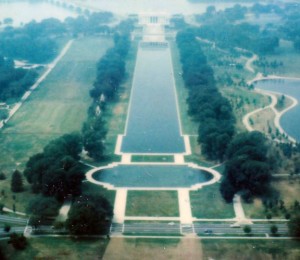
National Mall looking east
The National Mall from the Washington Monument looking towards the Lincoln Memorial, 1979.

My parents and I visited the White House, as well.  I seem to recall that we entered through the North Portico, and the light fixture there certainly looks familiar.  It looks like my memory might actually be accurate.  The White House website says that the North Portico was “(o)nce the principal entrance to the White House for both the family and the public.”  These days it looks like the visitor tours leave through that door. It was a house.  A very nice house, but a house.  Not so much with books and plants (the rose garden is supposed to be very nice, but I don’t think we spent much time there).

At some point we took a side trip to Mount Vernon, which was where George and Martha Washington lived.  It was another historic house. I do remember George and Martha Washington’s graves and being disappointed that so many of the outbuildings were reconstructed and/or replicas.

National Geographic December 2013, Part 1

To Walk the World, by Paul Salopek, photographs by John Stanmeyer

And finally I reach the beginning of the Out of Eden Walk series.  From now on, all posts on this topic will be in chronological order.

In this introductory article, Salopek explains his motivation for attempting this walk. He tells us how he wants to understand how small groups of a couple of hundred humans who originally left Africa, came to dominate the globe in such a relatively short space of time. He says that he wants to take this at the pace of a human’s walking speed so that he can learn everything he can, and also to document “current events as a form of pilgrimage.”  He will be following humanity as it spread out from Herto Bouri, Ethiopia, where the earliest human relics have been found, and eventually end up in Tierra del Fuego, Chile.

In this article, Salopek starts out at Herto Bouri, then goes northeast to Djibouti.  I feel the need to warn for one graphic image. On page 46 of this issue, there is a picture of a dead body on a lava field.  The body is in what looks to me to be an advanced state of decomposition and one can see some of the bones.

There is a map of Salopek’s expected path, and it looks to me, two years later, that he’s behind schedule.  There are years given, but no indication whether they are the beginning, middle, or end of the year.  The point for 2014 is in Tajikhstan and the point for 2015 is in India.  As of October 27, 2015, Salopek was in Georgia, which means he hasn’t even made it to that 2014 marker yet. So I guess we’re looking at this project going on until 2018 at least, rather than ending in 2017.

Ghost Cats, by Douglas Chadwick, photographs by Steve Winter

Ghost Cats is about the status of the American cougar in the United States.  The cougar is an apex predator, which means that a lot of humans are afraid of them. As a result, they have been driven out of a lot of inhabited places, which has thrown the ecological balance out of whack. But cougars are making a comeback. Scientists are tracking them with collars and cameras and observing their behavior, and the behavior of cougars is nothing like the scientists expected.  They expected the cougars to be largely solitary, but they seem to share space and prey fairly easily.

One of the reasons why humans don’t like cougars is the fear that they will kill livestock, pets, and be competition for prey with human hunters.  But it looks as though once a male gets established, a lot of the mayhem that humans have come to expect from cougars. One male being in charge of an area seems to reduce the number of other males that come into the area looking for food.

The photographs that accompany this article were largely taken with automatic cameras. And the camera must be very fast indeed, because the photos are so clear and crisp that they look almost like photographs of taxidermied animals, rather than living ones.  I looked carefully for any indication that taxidermy was involved, but all of the pictures seem to indicate that they were of living animals.