National Geographic May 2013, Part 3

Element Hunters, by Rob Dunn, photographs by Max Aguilera-Hellweg

Element Hunters, aside from the annoying faux-periodic-table font they used for the title (“N,” “H,” and “U” have atomic numbers thank you very much. They don’t need fake ones attached to them by the graphics layout people at National Geographic) has the also-annoying misuse of the word “hunters.” The title makes it sound like the scientists in question are looking for existing elements. They aren’t hunting for elements any more than my cousin used to hunt for poodle puppies (hint: she bred them).

The titular “hunters” are using a cyclotron to throw protons and electrons at each other in an effort to create a new element that will remain stable. So far, they all have so many particles that they are pulled apart after the tiniest fraction of a second. I kind of doubt that we’ll ever find a stable element with that many protons and electrons, but it’s a hobby, I guess.

China’s Grand Canal, by Ian Johnson, photographs by Michael Yamashita

In this article, we travel with Johnson to the city of Jining and then spend two weeks on a barge carrying a load of coal down the canal to the Yangtze. Along the way, we learn the history of the canal, which was begun when Emperor Yang wanted to carry rice from the north to the south. The major rivers of China run east-to-west, so Yang had “a million” people dig a canal running perpendicular to the rivers. The canal used to start at Beijing, but much of the northernmost section is filled in now.

South Texas Destinations: Comanche Lookout Park, San Antonio, Texas

Alex and I went to Comanche Lookout Park a couple of years ago when I was first playing around with the idea of starting a travel blog. San Antonio has such a wealth of parks and I thought that it was a real shame that I never really got out of the Brackenridge/Walker Ranch/Hardberger/Eisenhower/Denman Estate rut that I was in. So I started to research parks and discovered that Comanche Lookout has both geographical and historical interest.

The geographical interest is that Comanche Lookout Park is the fourth-highest point in Bexar County. And since Bexar County is pretty hilly, that means something. The elevation of Comanche Lookout Park is 1,340 feet.  That’s nearly 400 feet higher than the very highest point in Cook County.

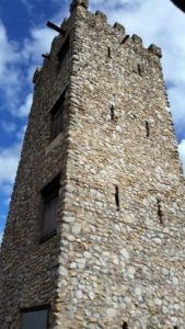
As to history, the local Native American nations, the Apache and, later Comanche, used the hill as, well, a lookout post, just as the name implies. Later, the Camino Real de los Tejas (not to be confused with the Californian Camino Real), which connected Mexico City to Laredo, San Antonio, and Nacogdoches, Texas went past the hill. That part of the road is known as Nacogdoches Road today. In the 1920s, a man named Edward H. Coppock bought the land that includes Comanche Lookout and he began work on a castle at the top of the hill. He never finished his castle before his death. A later owner razed all but the foundations and the completed tower at the top of the hill. The property was passed from owner to owner for nearly 50 years. The City of San Antonio purchased the parcel in 1994 and converted it into a public park.

Comanche Lookout Park tower, 2014
The tower at Comanche Lookout Park, 2014

Comanche Lookout Park has 4.55 miles of walking trails and one of those outdoor fitness systems. You know, the “do pullups on this bar,” “hold this bar and do pushups” things. There is a city library on the corner of Nacogdoches and Judson Roads. And, of course, there is the tower (see image), which is surrounded by a fence.

I seem to recall that a large number of the trails are paved, but the path to the top of the hill might be a level 3, and thus unusable by people in wheelchairs without really good upper body strength or a really powerful motorized chair.

I’ve Missed a Couple of Days

I applied for a couple of jobs on a whim and actually ended up with one job interview. I won’t know how I did until sometime next week, but it’s been hard to focus on pretty much anything besides that interview (particularly since I went out and bought a whole new outfit — shoes and everything — for it) in the last few days.

I’ve been thinking about the before and after of our trip to Yellowstone.  My checklist included:

  1. Find my ancestor’s baptismal record;
  2. Visiting Temple Square
  3. Seeing the Great Salt Lake
  4. Visiting Golden Spike National Monument
  5. Seeing a bison
  6. Seeing a bear
  7. Walking at least 100 yards from a paved road at Yellowstone
  8. Leaving the path entirely at Yellowstone
  9. Seeing Old Faithful erupt (and recording it if possible)
  10. Visiting the Old Faithful Inn (and eating there if possible)
  11. Visiting Dinosaur National Monument
  12. Seeing the petroglyphs at Dinosaur National Monument
  13. Visiting five different states

And I may have done the first. The record I found was for the correct date and the surname starts with the correct three letters. Unfortunately, as helpful as the people at the Family History Library were, no one there that day spoke Russian.

I did the 7th as a technicality. The park ranger directed us to a path that was fairly well traveled (and thus not terribly likely to end up with us disappearing without a trace or anything) and, as it turned out, 212 yards of it were unpaved. As a result, for 12 yards in the middle of the path, we were technically 100 yards from a paved road. We also made a sharp left into the woods and walked for a total of about a hundred yards, but we had to turn right to get around an obstacle, so we ended up less than 100 yards from the path.

And we got four of our five states in. We never made it to Colorado, since it was really late when we got to our hotel in Vernal and I just didn’t have the energy to drive any longer that night, even if Colorado was only a half hour away. And the next day, we got a later start than I would have liked, so we had to head back to Salt Lake City and didn’t get to go to Colorado that day. But I still got to visit Utah, Idaho, Montana, and Wyoming, so four out of five isn’t bad.

Alex and I leave for Chicago early Monday morning, so I’m going to type up my next National Geographic post tonight or tomorrow and perhaps write up Golden Spike National Monument as well. Those will be my posts for August 8 and 10, and by the 12th we’ll be home.

South Texas Destinations: Cibolo Nature Center, Boerne, Texas

Alphabetically, Brackenridge Park should be the next park up, but I’ve already covered Brackenridge Park here and here and here. So, skipping over Brackenridge, we get Cibolo Nature Center in Boerne, Texas.

We’ve been visiting Cibolo Nature Center since, oh, 2003 or so. I remember visiting it for the first time in the summer, and the sun was beating down on my hair pretty relentlessly (so that leaves out 2002; I didn’t have a whole lot of hair in the summer of 2002, I was still recovering from chemo). After the discomfort of the heat from the sun, I didn’t want to return again until fall. Once we went back, though, it didn’t take long to become one of my favorite parks, despite the half-hour drive it takes to get there.

The land which is now the Cibolo Nature Center was once just the back end of Boerne City Park (despite the name, there actually are other parks in Boerne). Prior to that, the land had been part of the ranch of Dr. Ferdinand Herff. A group formed to protect the section of Cibolo Creek that runs through this section of the park and also to preserve the little bit of wetlands that existed on the site. The city agreed that this was a worthwhile goal and the Cibolo Nature Center was established.

There are three miles of trails in Cibolo Nature Center,around two miles of which are named trails. These include the Marshland Trail, which leads out into the wetlands portion of the park, the Native Texas Prairie Trail, which leads out into the prairie at the center of the park, the Cibolo Creek Trail, which leads along Cibolo Creek, and the Woodlands Trail, which continues out into a wooded area farther along.

The Cibolo Creek Trail made me think of Middle Earth the first time I saw it, and it took me a while to realize why. The mass-market paperback edition of The Hobbit that was popular when I was young had Tolkein’s painting of the barrels with the dwarves in them escaping downstream and the view of the cypresses that line the banks lead to not a terribly different image.

They have at least in the past done controlled burns of the prairie area. This makes sense, because burning is an important part of prairie management. Without periodic burning, trees would eventually take over the land. Anyway, the now-ex, Alex, and I were in the prairie just after a burn once and we found something’s pelvic bones in the field. It seemed awfully small for a deer, but I’m nothing like an expert on osteology. At any rate, we didn’t want to disturb it, so we told one of the employees what we’d seen and where it was.

We had nicknames for most of the parks that we visited while Alex was young.  The nickname that we had for for Cibolo Nature Center was “the dinosaur woods.” The “woods” part is pretty obvious, I think. The “dinosaur” part is one of the neatest things about the park. In 1997, there was tremendous flooding in this region. One of the side effects was that dinosaur footprints were exposed by the flooding near Boerne Lake. The city decided to preserve them by paving them over, from what I read, but prior to that, they made a cast of them and put the cast in the Cibolo Nature Center. It’s pretty easy to find the tracks from the parking lot. When you stand in the parking lot, you can see the pavilion (this is also where the restrooms are located). The path kind of skirts the pavilion and heads off to the right (as you look at it). The footprints are along that path.

The Marshland Trail is designed to be wheelchair accessible. The rest of the paths are largely pretty level, but unpaved. The path down to the creek itself is pretty steep and kind of rocky, so I’m not sure about getting too close to the creek in a wheelchair. I can only think of one staircase on the paths, and that leads up the side of the bluff between the Cibolo Creek Trail and the Woodlands Trail.