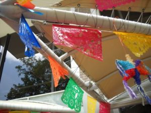
Fiesta de los Reyes, 2017

I finally made it to exactly one Fiesta event this year, the Fiesta de los Reyes at Market Square. The “Reyes” of the title is, specifically, the Rey Feo (literally “ugly king,” but some of our Reyes Feos have been quite attractive in my opinion). From what I can gather, the man who becomes Rey Feo is the one who raises the most money towards a scholarship program.

The Fiesta de los Reyes came across as a pretty standard street festival. Fortunately, I love street festivals. There were several stages set up (one under Interstate 35, one on San Saba Street, and at least two down Produce Row).

Okay, you’re going to need some kind of a map. I may have zoomed in on this a bit much, but here it is:
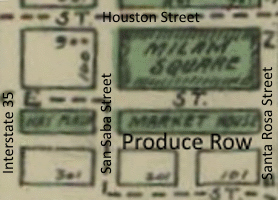
1908 San Antonio Map of the Market Square area
Map of San Antonio from 1909 (and thus in the public domain) showing where Interstate 35, San Saba Street, and Produce Row are (also Houston and Santa Rosa Streets and Milam Park, for reference).

Interstate 35, of course, wasn’t there yet in 1909, because the Interstate System wasn’t even authorized by Congress until 1956. The US Numbered Highway system (things like US Route 1, US Route 6, US Route 30, etc.) wasn’t even in place yet in 1909.
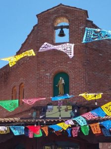
Probably St. Anthony, Market Square, San Antonio 2017
I’m pretty sure that this is St. Anthony. I’ve been to Market Square a couple of times in the past, but never noticed that little alcove up there before.

The bands that were playing when we were there in the early afternoon were a Mexican group called Dynastia Moreno (unfortunately, I’m not that familiar with Mexican musical styles to be able to identify their style of music. They sounded good, though), a Christian gospel/blues band called, well, Rev. Blues (they’re Texans, but blues bands always make me homesick for Chicago), a cover band of what looked like teenagers that was playing “Enter Sandman” as we walked past, and some other band at the Santa Rosa and Produce Row end of Market Square on a stage on the steps of the old Museo Alameda, which is now the Centro de Artes of Texas A&M – San Antonio. Unfortunately, it was too crowded for me to be able to read the signs giving the names of those groups. I figured I’d be able to look them up later, and I’m having no luck at all with that yet.

The Museo Alameda was an experiment on the part of the people at the Smithsonian. The Museo Alameda was a museum for Latin American art that was a full affiliate of the Smithsonian. It didn’t really catch on, unfortunately, and only five years after it opened, the Museo Alameda closed its doors. San Antonio still has a Smithsonian affiliate, though. Since 2014, the Witte Museum has been a Smithsonian affiliate.

That reminds me, the new upgrades to the Witte are done and Alex and I visited it and took even more pictures. I have to post that soon.
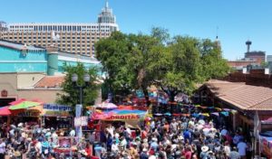
An overhead view of the crowds at Fiesta de los Reyes, 2017
See what I mean about the crowds?

And, as I said before, Market Square was packed with people. It was a lovely day in the mid- to high 70s, so Alex and I had more energy than we do during the summer months, but it was even a little crowded for me, and I generally love the hustle and bustle of public festivals. So we walked once around and got a little of the fiesta spirit, took some pictures, and then went home. The “walk once around,” by the way?  Took an hour and a half.


Fiesta San Antonio

Fiesta is the biggest party of the year in San Antonio and I’m afraid that I haven’t fiesta-ed nearly as much as I should have as a travel blogger.

I guess we probably should go back to the beginning. Well maybe not all the way to the beginning, because that’s when groups like the Apache, the Comanche, the Caddo, and the Coahuiltecans were the only humans in this area of North America, and that’s beyond the scope of this post (I may share some of that part of the history of the area when I write about the various mission).  In the 17th Century, the government of Spain decided to expand New Spain, which was located in what are now Florida and Mexico, into the mainland of what is now the United States.

In 1810, Mexico (which included most of the southwest of the United States, which included parts of Colorado and Wyoming) began an 11-year process of gaining independence from Spain.

Well, once Mexico had its independence, Texas apparently decided that this was a pretty good idea, and so they fought a roughly six-month war against Mexico from October of 1835 until April of 1836 (you see that April there? we’ll be coming back to it in a minute).

The first major battle was fought in San Antonio on October 28, 1835. This was the Battle of Concepcion, so called because it was fought on the grounds of Mission Concepcion. The Mexican soldiers took comparatively heavy losses and retreated, making this a win for the Texians (yes, that “i” is intentional — it was the demonym for Texas back then).

Things wouldn’t go so smoothly on March 6, 1836. This was the date of the Battle of the Alamo, in which somewhere in the neighborhood of 200 Texians  were killed and Mexico was declared the winner. Most of the bodies of the slain Texians were cremated on pyres near the site of the battle. The exact sites have been lost to history, but I have heard that the place where the San Antonio Fire Museum is currently located may have been one, and others may have been along Commerce Street.

Then, on April 21, 1836, the two armies faced off for the final battle of the war near present-day LaPorte. Ultimately, the battle, known as Battle of San Jacinto for reasons that I can’t quite get confirmation of, took 18 minutes. The Mexicans retreated and the Texians reportedly chased them down, killing as many Mexicans as they could. Nobody ever said that the Texians were good winners.

In the late 19th Century, the city of San Antonio decided to mark the anniversary of the Battle of San Jacinto with, well, a party. Originally called Fiesta San Jacinto, the centerpiece of Fiesta was the Battle of the Flowers, which was sort of like the Tournament of Roses Parade, if people would rip the flowers off of the floats and throw them at each other. Look, I’ve lived in Texas for 24 years, as of next month, and sometimes I suspect that I’m no closer to being able to explain Texans now than I was back in 1993.

Fiesta San Antonio decorations, 2014
Plastic papel picado decorations on the River Walk, Fiesta 2014

The name was changed to Fiesta San Antonio in 1960 and Fiesta is now ten days long, beginning the Friday before April 21 and ending not that next Sunday, but the Sunday after that, so an entire week and two weekends. The day of Battle of the Flowers Parade is a day off for many, including all teachers, staff, and students of the schools of San Antonio.

In my 24 years here, I’ve never gone whole-hog for Fiesta. I’ve been to Fiesta events at the Botanical Gardens and I think maybe the zoo once. My mother and I went to Fiesta San Fernando, which is music, dancing, and food in Main Plaza one year, I even attended the Battle of the Flowers Parade in 2014 (it was a parade; except for the Fiesta princesses on some of the floats, it didn’t look much different from the Fourth of July parade in my Chicago suburb home town), but not much else.

I began writing this post on April 28, which was Battle of the Flowers Day, but it took several hours to compose and so now it’s Saturday. Later today, if I can get the energy up to do so, I hope to rectify some of my Fiesta non-participation. I hope to make it to Market Square for their Fiesta event and if I can hack the hour walk there and back, I might check out the King William Fair, as well.

But, before I can even consider doing any Fiesta-ing, I’d better get some sleep.

Plans for Our California Trip

I think I’ve updated y’all on the plans. At first we planned to go to Europe this year. We planned to fly into Amsterdam, then visit Rotterdam, then into Germany, where we would go to Berlin, Munich, and Heidelberg (stopping at Neuschwanstein just because). After that I had hoped to visit Brussels before going back to Amsterdam for the flight home. In my dream version of this trip, I hoped to stop off at Baarle-Hertog and Baarle-Nassau, the two towns of Belgium and the Netherlands, respectively, that are sort of intertwined with one another.

Late in 2016, we scaled that trip down to a trip to Canada. The plan was to fly into Toronto, then drive a rental car to Quebec City, where there is going to be a tall ship regatta this summer. But Alex made a friend in California and really wanted to visit there, so early this year, we scaled it further back to a week in Southern California.

I just realized this last week that one of our traditional July trip destinations is a national park. In 2011, we went to the National Mall; in 2012, it was Hawai’i Volcanoes National Park; in 2013, we had Great Smoky Mountains National Park, Fort Raleigh National Historic Site, the Wright Brothers National Memorial, *and* Cape Hatteras National Seashore; in 2014, it was Parco Nazionale del Vesuvio; in 2015, it was Statue of Liberty National Monument; and in 2016, it was Golden Spike National Historic Site and, of course Yellowstone.

But what to do in Southern California? I was hoping to get to Catalina Island while I am in California, since I’ve never been to Catalina before, but it’s expensive. Channel Islands National Park is less expensive so it was tempting, but apparently you have to pick one island, and the closest island is still an hour away by boat, and the boats leave from Ventura, which is an hour from our hotel. So that’s a four-hour round trip. And apparently there’s not really anything to do on the islands unless you like to kayak, which doesn’t seem like my sort of thing. There’s not even a place to take shelter from the rain on Anacapa, which is the one that’s only an hour-long trip.

If the boats traveled more like the ones at Statue of Liberty National Monument, where you could take one boat to Anacapa, then another in an hour or two to Santa Cruz, and so on, it might be worth it. Take a boat to one island and be stuck there for the rest of the day is less exciting for me (oh, and apparently the seagulls are nesting on the island in July, so it’s apparently noisy and smells like seagull poop). This means, of course, that if I want to go to an island, I’m back to considering Catalina.

In contrast, our hotel is about two hours away from Joshua Tree National Park. I’ve been looking at pictures and doing some reading, and you can see the San Andreas Fault from there, and there are a couple of oases in the park.  So if I’m going to spend four hours in a rental car to get to and from a national park, Joshua Tree gets my vote.

Update on My Diabetic Cat and A (Actually Travel-Related) Thought

So we’ve been doing the insulin shots for just about a week now. I say just about because we had a bit of an adventure. I gave Kiliamo his first shot on Saturday, April 1, at 7:00 pm. Then I got up at 7:00 am on April 2 and gave him his second. While I was showing Alex how to draw up the insulin, he bent the needle of the syringe and we had to start over. Somehow, we ended up knocking the vial off of the counter and it shattered.

So I called the vet to leave a message asking for a new vial and we had to just hope that another 13 or so hours without insulin wouldn’t cause any damage. Monday morning, I got a message from work asking if I would come in an hour late to cover that shift instead of my original shift, so I planned to get up whenever the vet called and get the insulin. When they hadn’t called by 9:30, I called. The new vial was ready, so I went to get it. While I was driving back from the vet’s office (the only way to make it easily back from the vet’s is to continue down that street, turn at the next corner, and come back up a different street), I get a text asking me to come in right then. Well, I hadn’t eaten, or showered, and still needed to give the cat his insulin. I said I couldn’t be there for less than 45 minutes (and that would have required me to eat while I drove), and someone else offered to come in instead. So I was back to the later shift.

By the time the cat got his insulin, though, it was after 10. When you move a cat’s insulin dose, you’re supposed to move it in half-hour increments. Moving it half an hour at a time, I would have ended up late for work on Wednesday. So I ended up moving it in 35-minute increments, and now he’s back at 7:00 a.m. and 7:00 p.m.  I’m going to have to move the doses again in June, because Alex stays with his dad for the month and so I’m going to have to work only the late shift and give him his dose at 10:00 a.m. and 10:00 p.m. for the duration.

Well, it’s definitely been an experience.

In other news, I am often after Alex to take pictures of things and places that he thinks is important or memorable, because they won’t be there forever. I’m having that kind of experience on two levels right now. I was just at North Star Mall getting my pedometer steps in and I remembered that the mall has a basement. When my now-ex and I moved here, it was an Oshman’s Sporting Goods store. And as I walked around the mall, I could not remember where the escalator to the basement was. I think I’m pretty close, but still not quite enough.  I wish I’d thought to take a picture, if not of the escalator, of the spot where the escalator had been once it was gone.

The other thing is that the Santa Anita Derby horse race was today. I’ve been past Santa Anita Park in Arcadia, California. The first time my now-ex and I went to California, I borrowed the rental car while he went to work and we agreed that I’d find a pay phone and call him at some specific time (I think it was 3:30?) so we could arrange when I’d come pick him up. I passed the racetrack at pretty close to the time we were supposed to talk and I went to a supermarket to make the call.

There was a brief pause there while I gave my cat his insulin. Where was I? Ah, yes, Santa Anita.

So I’ve looked for a supermarket near the racetrack a few times and can’t find anything. This summer, Alex and I will be staying in that part of the Los Angeles area, so I’m hoping that I’ll be able to find that supermarket again. I’m certainly going to try. It was more than 20 years ago, so the area has probably changed irretrievably (?), but just maybe I’ll get lucky and find that store again.