Blogging Plans for 2019

We have about an hour left in 2018 and so I’m making plans for 2019. I was thinking that I could knock out the rest of the parks on my list of parks if I visited one a week but that doesn’t seem likely since I lost count around 120.

So if I visit a new park a week, I’ll be able to string that along for at least two more years. Alex and I went to the Japanese Sunken Gardens on Christmas, and if my records are right and I haven’t written about them, that’s probably where I’ll start.

Alex wanted to walk up above the crowd, but I really wanted to get over to the waterfall (picture to follow later, probably) and I literally said, without planning to at all, “I want to go down there. Where the people are.”

So, tomorrow I’ll start working on my new post and you’ll just have to wait to see if I did get to go where the people were.

24 Hours of Happy: 3:00 to 4:00 p.m.

And, today, to give Pharrell Williams some money, we have his 2014 album G I R L. (and also some non-breaking spaces I wonder if they worked?)

3:00 pm Ah. Okay. This is the part with the choir from the video. We stay inside the church for a while, finally emerging into the afternoon sunlight at around 3:13. We head north on Marengo until 3:16.

3:16 We’re somewhere else. Again. Are we still somewhere in Pasadena? Are we back on Vermont? Dunno. It looks like a residential neighborhood with broad streets. I can see a street name. It starts with an “A.” “Algernon”? “Algonquin”? “Aloysius”? No parking. Bike route. A guy doing The Pony this time. Another illegible street name. Pine trees.*

3:20 Wow this guy’s backlit. It’s almost like one of my photos. Wait – there’s a sign. Let’s go back. It might be a hospital sign I can see “Main Entrance” and “ICC.” Another agave. There’s a big building with a tile roof in the background.

3:24. We’re not in the same place, but it sure looks like the same big building there. From this angle it looks like maybe an apartment building? Yet another illegible street name. And another – no, wait. Does that say “Mt. Pleasant”? Let’s try that out.

This could be it. We start out on Campus Road and Alumni (that’s our “A” street name) near Occidental College.** We follow the street (which is lined with pine trees and has a sign that says “ICC” on it) and just before we make a left onto Stratford, we can see a large building with a tile roof behind us. Mt. Pleasant makes a T junction with Stratford.

3:32 We’ve moved again. I think. Did we move at 3:28? No, I think that’s where we left off. We cross Avenue 49 in the right place. The background matches. The fences match. That’s the same mailbox.

That flowering shrub is the same.

So that house on the corner must have really changed.

I guess that is the same house. Amazing what a coat of paint and a deck will do.

The train of her wedding dress will be really grubby after dragging it along the street like that.

Oh! And we’ve turned onto Avenue 50 and are headed southeast. Then we make a left onto Meridian. I wonder what this bride’s story is. Is she a model or is that her wedding dress. Pharrell got married in 2013, didn’t he? Is this his wife?

No it doesn’t look like her. And that’s doesn’t look like what his wife wore at their wedding so probably not.

3:36 Rush hour must be starting or something. Those vehicles are driving right past that young woman (and, presumably, the entourage walking ahead of her). I wish I knew where in the block she was right now. ‘Cause there’s something in the middle of the sidewalk there and I wonder if it’s a permanent fixture or what. Oh, wait. We’re at the end of the block. And I don’t see anything on the sidewalk there, though it could be behind one of those cars***.

We cross Avenue 51 and I really need to go to bed. We’re hoping to go state parking tomorrow.

(the next day)

We make a left onto Avenue 52 and we might not have time to go state parking today. We both overslept.

We eventually find ourselves making another right back onto Stratford. Our next dancer is wearing high-heeled footwear of some sort (we’re still pretty backlit here, but I think they’re boots) and she looks a little unsteady on her feet, like she has either walked or danced in these heels but not both together.

3:48 We’re on a sidewalk. Are we still on Stratford? I see a steeple-looking thing there. Let’s see if I can find it on Google Street View. Yep. There it is. I wonder what it is. I know how to get back here from there.

It’s the Iglesia Adventista de Highland Park. It’s kind of a cool-looking building. Their Facebook has the name in English (Highland Park Seventh Day Adventist Church) but the information on the page is all in Spanish.

Oh, I can hear my late mom now. “She’s not dancing. She’s just posing.” We get the occasional dance step from this young lady, but overall, it feels more like she thinks she’s a model in a fashion shoot than a dancer in a music video. We continue following Stratford after it jogs slightly north at Avenue 55. How far back do these numbers go? Is there an Avenue 1 somewhere? Looking it up, the “North Avenue #” names only look to go as far back as 16.

3:52 We’re leaving Highland Park and now we’re at a cemetery? I wonder what cemetery we’re in. It’s not Forest Lawn Hollywood Hills, I don’t think. Time to hit Google Image Search.

*I still don’t know where we were, months later.

**Alma mater of Ben Affleck, Matt Damon, and Barack Obama.

***for varying definition of “cars.”

2017 California Trip: Joshua Tree National Park

Every year, Alex and I visit some property of the National Park Service. In some years it’s a hardcore park like Yellowstone, others it’s a National Historic Site or something of that nature, like the National Mall or the Statue of Liberty. When we started planning the trip to California, I actually considered Channel Islands National Park for quite a while, but apparently they’re more fun for people who like to boat. And while I like to ride in boats, my only experiences with actually driving the boat involved me causing the canoe to capsize at Girl Scout camp.

So I went back to the proverbial drawing board and looked at the list of parks again. This time I did the math on Joshua Tree. I also asked a friend whose father is a retired park ranger and the friend said that Joshua Tree is a great place to learn about desert ecosystems. And with that I was sold. We ended up going to Joshua Tree.

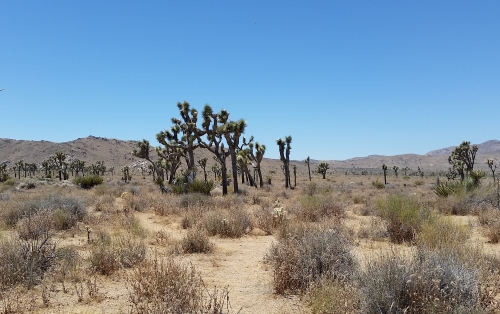
Joshua Trees, 2018
Joshua Trees at, well Joshua Tree

We intended to get up early and head out at about 6 or 7 am so that we could miss the hottest part of the day. Yeah. That didn’t work out so well. By the time we got there (quarter to noon) the only wildlife we saw was a coyote who was apparently running late.

We stuck to Park Boulevard for most of our visit, arriving at the West Entrance Station and leaving at the North Entrance Station. We took the Keys View detour to see if we could see the San Andreas Fault (which is visible on a clear day). Unfortunately, it was not a really clear day. It wasn’t cloudy, I don’t even know if it was smog. I’ve been toying with the image and I think I can see the fault. At least it looks like the thing that’s labeled the fault on other photos. It doesn’t look like any of the faults here in Bexar County, though, that’s for sure. We also considered hiking out to the Lost Horse Mine, but we didn’t want to commit that much time to the trip in the heat of summer. I think we did walk out a while, but didn’t get too far.

Overall, we spent three hours at the park and saw most of the northern half of the park. It looks like if you want to see most of the rest you’ll have to be a more intrepid hiker than I am.

I did bring the recommended amount of water (a gallon apiece) and I even used sunblock. I wear a face lotion with sunblock all of the time, but generally the rest of my body is left to its own devices. The informational signs were informative and the people we bumped into were friendly and maybe when I return to California someday I’ll take some of those paths that go out into the hinterlands. Not in the summer though. I promise.

Yay! It’s Gratuitous Amazon Link Time! And in what I’m sure is a complete surprise, I’m going to post a link to U2’s album The Joshua Tree in my article on Joshua Tree. An awesome album by an amazing band (and I hope they come to Texas again someday — I want to take Alex to see them).

24 Hours of Happy: 2:00 pm to 3:00 pm

2:00 to 2:25-ish I really thought that we were going to spend another hour inside Union Station. Then, around 2:25, the dancer walks out the front door of the station and . . . keeps going. We start out on Alameda and head south. We cross Alameda at Temple.

What temple is this street named for, I wonder. Oh, apparently it’s not a temple, but a Temple. Jonathan Temple, to be exact, a rancher who lived in the area and was the first mayor of Los Angeles. No relation to Shirley, I guess.

Are we going to go down Temple? It looks like it.

And we start to go northwest on Temple.

2:44 Now we have three guys . . . somewhere. You can see an underpass and a pink and gray building behind them. We passed a pink and gray building on Temple, but this one looks less pink and more gray, so I don’t think it’s the same one, but I’ve been wrong before.

Maybe this is the parking garage from 9 am? Judging by the public art piece there by the underpass, yes, it is the Grand Avenue parking garage again and we’re heading northwest on 4th Street. At the corner of 4th and Hope, we make a right onto Hope.

2:48 4th and Hope was nice while it lasted. We’re somewhere else now. I see a sort of plaza with trees. I see buildings. I see a bicycle lane. I see Pharrell in Union Station (I goofed and restarted the video instead of pausing). There’s a bus shelter and a blue-and-white sign not entirely unlike the sign for Good Samaritan Hospital. Are we back over on that side of town?

Ah-ha! The words “Federal Building.” That should help us narrow it down. Are we back on Temple, maybe? A lot of the governmental buildings are out there.

We’re now on Los Angeles Street again, this time between Temple and Aliso. The blue sign is for the Los Angeles Mall. We cross Aliso and then go over the 101. Well, the dancers do. I somehow click in the wrong place on the Street View and end up on the 101.

Okay, I’m back on Los Angeles.

We continue north and pass a lady with a doggo. The dancer stops to pet the pupper and we see a man arrive with two more dogs in a stroller. There’s a lot of greenery nearby, so I wonder if there’s a dog park near where we are. So I look it up and we’re near Father Serra Park, which doesn’t seem to have a dog park.

In fact, Los Angeles has only nine dog parks that I can find. San Antonio currently has 11 dog parks. That’s one dog park per 441,000 Angelenos and one dog park per 136,000 San Antonians. Los Angeles had better get on the ball.

We cross Los Angeles and guess what we see in the background? If you didn’t guess Union Station, you’d better keep guessing until you do. Because that looks to be where we’re headed. Union Station is sure a pretty building and is framed very attractively at around 2:55:45 or so. I just kind of wish we’d spend some time somewhere else. Particularly since we’re burning daylight here.

I missed a day during the 2-2:59 hour because I had some kind of digestive thing. It may have been my motion sickness cropping up, it may have been something I ate, it may have been an eight-hour bug. But either way, watching Beattie look up into the sky after each dancer and then back down at the next one was making my nausea worse.

2:56 Where are we going to start the 3:00 pm hour? There’s a sign for California State Route 110 and the building there on the right sure looks familiar. Have I seen it in real life or in this video or does it just have one of those facades?

More building and our dancer (a) is being photographed from an awkward angle or (b) has a little bit of a limp.

Okay, we’ve left Los Angeles proper now, I guess. The building is the First Baptist Church of Pasadena. And it looks like the Google Street View car went through this area at night during a blackout. Never mind. I was in Pasadena Texas and not Pasadena California. That would explain the darkness (if the car did go through that area at night). There aren’t a lot of streetlights out that way, I guess.

So we start out on Marengo in Pasadena and make a left onto Holly. I wonder what that building behind the dancer is. Google Street View isn’t helping (though there must be a field trip to whatever this building is, since there’s a school bus parked outside), so we’ll use Google-Not-Street-View. According to the old school two-dimensional map, the building is the Pasadena City Hall. Also, according to the map, we’re just a stone’s throw from the Colorado Blvd. Bridge.

Looks like we’re going into the church now. I wonder why Pharrell is indoors for so many of his top-of-the-hour segments.

2017 California Trip: Hancock Park and the La Brea Tar Pits

Okay, so one of the points that is often made about the name “La Brea Tar Pits” is that “la brea” is Spanish for “the tar,” so the name is the “The Tar Tar Pits.” But it’s actually worse, I guess, than that. because the name may have the word “Tar” in it — twice — but the substance that oozes out of the ground around that area is actually asphalt. Tar is  a similarly goopy manufactured substance made from wood (generally pine) or peat or even coal.

I’ve been to Hancock Park three times now, and neither Thomas nor I recognized it the second time we went. They’d apparently done some renovations in between our visits. I wonder if Thomas still has the pictures we took on our first visit. I have some fun memories of that first visit. Asphalt oozes up out of the ground randomly around there and on our first visit they marked those spots with traffic cones. Thomas and I watched a rottweiler try to run off with one of the traffic cones. The rottweiler’s person was *not* happy.

My mom always kept a diary of our trips, listing where we went and when we went there and sometimes I really wish I was in that habit because I cannot for the life of me remember which trip it was when Thomas and I went to the George C. Page Museum, which is kind of the centerpiece of the park. The museum holds most of the major discoveries that they’ve found in the pits and also has the labs where they clean the fossils.

I’m pretty sure that the first time I went to the museum was during our 1999 trip to Los Angeles, which was when I was pregnant with Alex (on this trip Alex and I put a lot of emphasis on returning to places where I had gone while pregnant with him). They were shooting some kind of program on, if I recall correctly, Jenna Elfman, at the museum and that helps not at all because I can’t find any such program. Of course, Elfman is a Scientologist, so maybe it was some kind of video for internal Church of Scientology use?

The park itself has quite a bit of interest. First, of course, there’s the famous (and kind of distressing) statue of a mammoth dying in a tar pit. There’s  also a lovely garden and when you look more closely, you see that the plants are all the same kind of plants that lived there when the mammoths, dogs, and other animals found in the tar pits lived there.

There is also an observation pit, which wasn’t open during any of Thomas and my visits, I don’t think, and was closed for the day when Alex and I were there.  Also, when they were building the parking lot for the Los Angeles County Museum of Art, they found more fossils. They put this material into 23 boxes and dubbed it “Project 23.”

Project 23 cases 5A and 16.
Okay, maybe “boxes” understates it a bit. These are some of the Project 23 boxes (and it took some doing to get this picture. I had to hold the lens of my camera up to a hole in a wire fence to get it). I think that’s part of the art museum there in the background

They aren’t planning to open any more pits to excavation, but between the boxes of Project 23 and the tar pits that are likely to be found while the city develops its subway system, they aren’t likely to run out of material any time soon.

Our Amazon link today is less gratuitous than usual. It’s the movie The Last Action Hero, starring Arnold Schwarzenegger. This link brought to you by Danny standing next to Jack watching Jack wiping the tar off himself and opining that tar sticks to some people.

24 Hours of Happy: 1:00 to 1:56 pm

First, let’s try to give Pharrell some money. I can’t remember if I’ve posted a link to his previous book, but here’s the sequel: Pharrell: A Fish Doesn’t Know It’s Wet.

Today in grousing about WordPress 5.0, when I copied-and-pasted this blog post from the original document, I lost random spaces somehow. I did not have this problem in WordPress-whatever-comes-before-5.0.

1:00 So are we going to start out in the same gym? Let’s find out.

Yes, we are. And Pharrell makes a bit of a show of flinching away from the boxers practicing around him. Our 12:56 dancer is exercising in the background for most of the four minutes that Pharrell is in the gym.

1:04 Looks like I’m going to be able to phone this one in. We start out on 4th Street and go right back into the gym.

1:16 Never mind. We’re outside now and it looks like we’ll stay that way for awhile. Will we explore the neighborhood? Stay tuned and we’ll find out. So far, so good. We go west-ish on 4th Street to Omar and then make a right. Google Street View has a tent village (like a tent city but smaller) there on the corner. It might not’ve been there in 2013 though. I wonder how many of these tents are the same people? They seem to move around. The tents that you can see from 4th in October of 2017 are different from those you can see from Omar in January of 2017.

Okay, so at Boyd and Omar we cross Omar and head up Boyd. Along the way, we pass some signs saying that this is a sightseeing bus zone. What sightseers would be in this area?*

We cross San Pedro at Boyd and we’ve been here before. I went back and checked. We were here at around 11:20 am.

We cross Wall Street and this, I think, is a new-to-us area.

1:28 We skip ahead almost a block to the corner of Boyd and Los Angeles and start to head southwest. Our dancer jumps up and touches a Minion pinata as he walks along, and on Google Street View, there’s still a Minion pinata hanging in that spot in January of 2017. I guess that this video has been good for business for that store. We cross 4thStreet and then Winston and make a left onto Winston. We also pass more of those Loading Only signs. I was beginning to wonder if they were put there by the crew for the video, but you can see at least one in the Google Street View in 2017.

At the corner of Winston and IDEK-At-This-Point**, we cross Winston and pass another Loading Only sign. I’m pretty sure we’re on Wall Street.What I can see of the background looks like the Anne Douglas Center for Women. How much does a pay phone call cost these days? It looks like it was still 25¢ in 2013.

At Probably-Wall and Most-Likely-4th we make a left. As Happy goes into its I-think-”breakdown”-is-the-correct-term, our dancer clutches at her chest like she’s suffering heartbreak or an asthma attack. I’m pretty sure that I’m in the right place. The doorway of (what is in 2017) L.T. Gifts is in the right place. I’m so glad I’m doing this project only five-ish years after the video was made. In a few more years, God only knows whether I’d be able to find enough landmarks to identify where we are.

We turn into another alley (how many alleys is this now?), only it turns out that this alley is a shopping area of some sort. We emerge from the alley onto Winston, I think. Then, just before we get to Los Angeles, we turn into another alley. If I’m right about where we are,we’re going to come out on 4th Street. Let’s watch.

Actually we don’t end up on 4th. There’s another alley within that alley and we make another right down there. As of 1:45, we’re inside a building. I’m so confused. I hope we come out onto Wall Street or I’m going to have to go back and figure this all out again. Please don’t make me have to go back and figure this all out again.

We make a left onto whatever street we’re on.

Yes! We’re on Wall Street. I can see Cap Star*** behind the dancer, and Cap Star is on Wall Street. We make a right onto 4thStreet.

1:48 These three young men are celebrities of some sort. Their names,Tyler the Creator, Earl Sweatshirt and Jasper Dolphin, mean nothing to me. They are, from what I can tell from Wikipedia, members of a group called Odd Future Wolf Gang Kill Them All. I hope you can hear the dubious tone of my typing. And I also hope you kids get off of my lawn.

We seem to still be where we left off on what is likely to be 4th Street and I’ve been reading entirely too much Breaking Cat News, because for a brief moment, I think that the cat on the middle young man’s shirt is Sophie.

We are on 4th Street, but I was going the wrong direction. I thought we were going northwest, but we were going southeast. We should be passing the LA Sands gym soon, right? Or am I hopelessly lost?

We cross San Pedro and keep going down 4th Street.

1:52 More Pony.

1:53:37 We’re crossing Crocker Street, which does, in fact, put us a block northwest of the LA Sands gym. Will we make it all the way back in the next two and a half minutes?

1:55:30 If my calculations are correct, that should be the corner of 4thand Towne and the LA Sands gym should be right across the street. I’m doing that moving back and forth changes the scene thing again.Nothing as dramatic as the destruction of the 6th Street bridge, but boy, does this corner change between January and October of 2017.

Three of these four corner buildings must have been bought by the same people in those ten months, because they’re all the same shade of blue in October. Well, either that or a very persuasive blue paint salesman came through in that time, I guess.

And now, 1:56.

Oh, goody. We start out indoors. I hope we get some kind of hint where we are at some point in the 1:56 to 2:55:59 hour. Otherwise this will be another hour that I skip.

I stand corrected. We’re in a courtyard of some sort. The things that I assumed were pillars are about half pillars and about half palm tree trunks.

1:56:50 And now we’re indoors. Dammit. A sign says something about Metrolink trains as we go down an escalator, so maybe we’re going into the subway?

We are in the subway. I don’t know what station we’re at, but I can see that both the red and purple lines go there, so that looks like Union Station, the Civic Center, Pershing Square, 7thStreet/Metro Center, Westlake/MacArthur Park, or Wilshire/Vermont. I see people in USC shirts. We haven’t been to that part of the city yet. And the winner is Union Station. I can see the words “Union Station East Portal” above the entrance to the train platforms.

Some people step off to one side to stay out of the shot, but I guess they figure out that they’re in the shot because they keep walking after a moment.

*I did some digging later and this is just around the corner from the Little Tokyo Historic District. So those tourists, I would imagine.

**We’re way too close to the dancer. She’s very pretty and is wearing a very brief top, but some of us are here for the other scenery.

***A store that sells baseball caps. Not the flea medication.

San Antonio Area Parks: Orsinger Park, San Antonio

I considered revisiting Orsinger Park the day I visited MacArthur but then I realized that I really didn’t need to because I still go there fairly often, largely to play Pokémon Go these days.

But Orsinger has always been one of the parks we visited fairly frequently when Alex was young because it’s the only park we’ve found so far that had a sandbox. Orsinger was the sandbox park, Walker Ranch was the airplane park (because it is in the landing pattern for the airport), and Cibolo Nature Center (have I written on that one yet?) was the dinosaur park (because it has a cast of the dinosaur footprints found near Boerne Lake).

Orsinger is one of the parks of the Bexar County Park system. The land was donated to the county by Genevieve and Ward Orsinger in 1980. Genevieve was a dancer and a teacher (the Genevieve and Ward Orsinger Foundation website doesn’t say what she taught, but since her degree was in physical education, my guess is that she probably was what is colloquially known as a “gym teacher”). Ward owned a car dealership.

Orsinger is a nice little park with a playground and a pavilion with an attached kitchen and a surprising amount of walking trails. The first time Thomas, Alex, and I left the playground area for the walking trails we kept expecting to come to the end of trails but we didn’t. I mean, of course we eventually did, because we’re not still walking around out there, or we didn’t die of dehydration or anything, but there were still a lot of trails.

And I just realized that I don’t have any pictures of Orsinger. I figured that I’d gone on a photographic trip there at some point, but I guess I was mistaken. So I’ll be taking a trip out there and editing this post later, I guess.

Orsinger Park Path 2018
Finally. A picture. This is just a little bit of the walking path at Orsinger Park.

I almost forgot my gratuitous Amazon link. This time the highest-ranked book I can find is Dirt Cheap Photo Guide to Grand Teton National Park by Jeff Clow.

Farewell Yellow Brick Road, a Longer Review

First, some more WordPress 5.0 grousing. I wonder if there’s some way to add, you know, visible lines outside this typing area. It feels weird just typing into a void like this.

I’ve seen most of my San Antonio concerts at the Tobin Center, the Majestic, or the Alamodome. My only times going to the AT&T Center have been for San Antonio Rampage hockey games, and one Spurs game. As a result, I thought that leaving an hour before the concert would certainly be enough time when travel time was only 20 minutes.

It totally wasn’t. After driving for nearly 50 minutes, the Uber left us off outside the building at 7:55 and then we had to get in line for security. And when the Uber dropped us off, there were lots of cars still trying to get in and when we were in line, there were lots of people in line behind us. One person behind us asked if we were sure the show started at 8 and that wasn’t when the doors opened.

I looked up the show at Setlist.fm it turns out that the first song we heard (while we were looking for our section), Bennie and the Jets, was the first song of the concert. So we didn’t miss much. I also think that a mohair suit sounds itchy.

I’m not going to go over the concert song by song, that’s what sites like Setlist.fm are for. Sir Elton’s voice is deeper now than it was when he first recorded most of these songs, courtesy of surgery on his vocal cords in 1987 and, of course, age has affected his voice as well, but he still gave an amazing concert.

He seemed to still have such joy in performing. I know he’s retiring from touring to spend time with his husband and kids, but I hope he continues performing. During one of the extended jam sequences (Levon, I think?), I wondered how someone who could play music like that could take drugs. I love music, listening to it and playing it (I sing and play the flute and piano and also have played in church handbell choirs) and I’m not amazing, but I always enjoy music so much that if I played anything like as well as Sir Elton does, I don’t know if I’d need any other high.

One of the most pleasant surprises of the night was Ray Cooper. Cooper is a multi-instrumentalist musician whose specialty is percussion. Sir Elton has gone on tours with Cooper where it was just Sir Elton on the piano and Cooper on percussion. He’s just that good. I was blown away and, as I mentioned in my last post, when Sir Elton introduced his band, I joined the people who gave Cooper a standing ovation.

I learned several things about Sir Elton that I hadn’t known before. The biggest one was that he hadn’t intended to become a rock star at all. He and Bernie Taupin (And why isn’t he Sir Bernard yet? Sure, Sir Elton is the face of the organization but the words are Taupin’s) had intended to be professional songwriters, but no one bought their songs, so Sir Elton sang them himself. Also, Taupin writes the words and then gives them to Sir Elton, who writes music to go with the pictures that Taupin’s words draw in his head.

I don’t know if it’s a Texas thing or an artifact of the fact that I’ve been focusing on seeing artists from my youth and so the other attendees are around my age and thus more . . . mature? old? boring? but I usually end up sitting among people who are not nearly as enthusiastic as I am to be there. The people behind us, for example, didn’t even applaud and when I looked back at them, their facial expressions looked like they were just waiting for the concert to end so that they could audit Sir Elton’s taxes or something.

So here’s the question. Should I: a. shell out more money for the next old person that I don’t want to miss and sit closer to the front? b. go to the next Reggaeton concert to come to town* and sit near where I usually sit and see if they’re more excited? c. go to see an old person somewhere else** and sit in my usual seat?

Gratuitous Amazon link time. This time, given the subject and the theme of the tour, I’ll choose Goodbye Yellow Brick Road. Also, this is the album that has my favorite of his songs, Candle in the Wind, on it.

*Nicky Jam is playing in Laredo in March. Since I think I’d have to go by myself, I don’t know if I feel comfortable spending two and a half hours on I-35 so that I can be the only 50-year-old white lady at a concert in a strange city where I don’t know anyone. Though I do hope to do more of that kind of thing once I leave Texas, so maybe I will. I have a couple of months to decide.

**Cher is on tour this year. Unfortunately, the closest she’s coming to Texas is Omaha. At least if I end up going to Omaha by myself, I might not know anyone but I know the city. I wonder if they’re running a shuttle from the Even Hotel like they did for Lady Gaga?

Farewell Yellow Brick Road, Elton John, AT&T Center, San Antonio, Texas December 12, 2018

This is my first post in WordPress 5.0 and I hope I adjust to this, because it’s making me crazy.

So I just came back from seeing Elton John live (my last-ever chance to do so, unless my dad wins the lottery between now and the end of 2020) and it was awesome. Sir Elton was awesome. The rest of the band was awesome. Ray Cooper* was awesome. The audience was awesome.**

And I fully intend to go on more about this later. Much later. Like, after I get a full night’s sleep and eat at least one full meal, which means it’ll have to wait until after work tomorrow night, probably. Good night.

*I’m one of the people who gave Cooper a standing ovation when he was introduced. Ray Cooper was really, seriously, awesome.

**Both in the sense that it was awesome singing “Ooh-ooh-ooh, ah-ah-ah-ah, Ooh-ooh-ooh” with them during Goodbye Yellow Brick Road and in the “I was in awe of how many people were there.” They were selling seats behind the stage.