Alex and I went to Comanche Lookout Park a couple of years ago when I was first playing around with the idea of starting a travel blog. San Antonio has such a wealth of parks and I thought that it was a real shame that I never really got out of the Brackenridge/Walker Ranch/Hardberger/Eisenhower/Denman Estate rut that I was in. So I started to research parks and discovered that Comanche Lookout has both geographical and historical interest.
The geographical interest is that Comanche Lookout Park is the fourth-highest point in Bexar County. And since Bexar County is pretty hilly, that means something. The elevation of Comanche Lookout Park is 1,340 feet. That’s nearly 400 feet higher than the very highest point in Cook County.
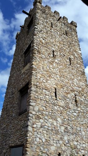
As to history, the local Native American nations, the Apache and, later Comanche, used the hill as, well, a lookout post, just as the name implies. Later, the Camino Real de los Tejas (not to be confused with the Californian Camino Real), which connected Mexico City to Laredo, San Antonio, and Nacogdoches, Texas went past the hill. That part of the road is known as Nacogdoches Road today. In the 1920s, a man named Edward H. Coppock bought the land that includes Comanche Lookout and he began work on a castle at the top of the hill. He never finished his castle before his death. A later owner razed all but the foundations and the completed tower at the top of the hill. The property was passed from owner to owner for nearly 50 years. The City of San Antonio purchased the parcel in 1994 and converted it into a public park.
The tower at Comanche Lookout Park, 2014
Comanche Lookout Park has 4.55 miles of walking trails and one of those outdoor fitness systems. You know, the “do pullups on this bar,” “hold this bar and do pushups” things. There is a city library on the corner of Nacogdoches and Judson Roads. And, of course, there is the tower (see image), which is surrounded by a fence.
I seem to recall that a large number of the trails are paved, but the path to the top of the hill might be a level 3, and thus unusable by people in wheelchairs without really good upper body strength or a really powerful motorized chair.
I’m running these out of order. I missed two, so I’m publishing this now and will follow up with Comanche Lookout and Cibolo Nature Parks in another week or so (maybe longer if I do end up exploring downtown San Antonio for Pokéstops in the next few days).
I have to admit that I haven’t spent that much time at Concepción Park. Alex and I explored a little, and it seems to be a nice addition to the neighborhood around there, with a swimming pool, a playground, picnic tables, and sports fields. Unfortunately, it is relatively low on shade and the only walking trail is only 0.5 miles (0.8 km). Alex and I were at the park primarily as a parking lot for the Mission Reach part of the San Antonio River Walk. Concepción Park, including the attached Sports Complex, are around 76 acres, which isn’t that large, but by my estimate, it’s around a mile along the river, which took us two tries, since we had our elderly dog with us the first time. We had to stop so that she would have the energy to make it back to the car.
My family and I have spent many happy hours at Friedrich Wilderness Park (post to follow later). One day when the now-ex and I were heading home from Friedrich, we passed a sign for a Crownridge Canyon Park. Curious, we turned at the sign and got utterly lost trying to find the park. We did see a wild turkey, however, when we accidentally drove into the parking lot of the Palmer Course at La Cantera, so there’s that.
This was back around 2006, in the days before everyone had Google Maps on their phones so we turned around and headed home. We figured out that we missed a turn onto Babcock and made another attempt a while later, but didn’t see the park then, either, due to having missed yet another turn that we didn’t know about.
I finally found the park for the first time sometime around 2009 or 2010 after my divorce and when my dad moved in with me and it really was worth the effort.
The area which is now Crownridge Canyon Park was, at one time, purchased by a company that wanted to put houses in that area. However, that land is in the Edwards Aquifer Recharge Zone and is also part of the nesting range of the Golden-Cheeked Warbler, both of which are pretty compelling reasons for the city to buy the land and mark it for public use. Eventually, from what I can tell, there is going to be one greenway including Crownridge Canyon, Friedrich, and the new Rancho Diana parks.
Crownridge Canyon is a great place for birders. As I mentioned, the golden-cheeked warbler and turkeys are both endemic to the area. The park also has bushtit and the last time we were there, Alex and I saw a really pretty (and still unidentified) blue bird in the parking lot.
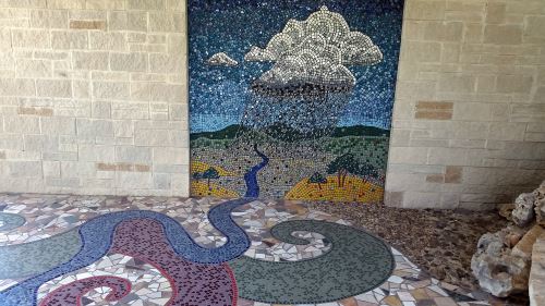
Oscar Alvarado, Hill Country Water Cycles, 2005 (you can see the rocks of the stream off on the right-hand side)
The park has a public art display, Oscar Alvarado’s Hill Country Water Cycles, which consists of a wall and floor mural and also a model stream created with collected rainwater. The drive up to the park may be worth it just for the artwork.
Crownridge Canyon has 1.8 miles of hiking trails in a sort of figure-8 shape. The bottom loop of the 8, which is 1.3 miles, is kind of steep, but paved, so people with quite a bit of upper-body strength should be able to make the path in a wheelchair. The top loop, which is 0.5 miles, is steeper and is unpaved, so it may be unpassable by wheelchair users.
So, since I’m not sure how to tackle over the 200 parks that I haven’t covered yet (many of which I haven’t even visited yet), I guess I’ll do this alphabetically.
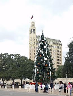
First of the ones I’ve visited, I guess, is Alamo Plaza. I didn’t even realize that Alamo Plaza was a park until I saw it on the San Antonio Parks and Recreation website. While Alamo Plaza has a fair bit of history — it was part of the mission complex for Mission San Antonio de Valero (the Alamo’s original name). Today, though, there’s really not much to Alamo Plaza. I don’t think that the Alamo itself is actually part of the park. The Alamo is owned by the Texas General Land Office and not the city. The plaza itself is largely paved with limestone. People gather there to socialize and street vendors (notably, if I recall correctly, raspa (sno-cone) vendors) sometimes have carts set up there. There’s a gazebo and the cenotaph, which is a giant monument listing the names of those who died in the battle of the Alamo. Also, Alamo Plaza is where the city sets up the city Christmas tree.
The 2015 city Christmas tree for San Antonio, Texas in Alamo Plaza.
Bamberger Nature Park is in a completely different part of the city — the northwest side. At nearly 71 acres (28.7 hectares), Bamberger is considerably larger than Alamo Plaza. I seem to recall that seeing a sign saying that before it was a park, Bamberger was a part of some family’s farm. I thought I took a picture of the sign but can’t find it now.
There isn’t a whole lot more to Bamberger Nature Park than there is to Alamo Plaza, only in the other direction. Where Alamo Plaza is all built up, Bamberger Nature Park is largely unimproved. The only real change made to the park are 2.5 miles of hiking and biking trails. These trails connect to the Leon Creek Greenway. I’ve been there twice, once intentionally in December of 2014, and the other one in the spring of 2016 when I made a wrong turn on the Leon Creek Greenway. Both times, it was a very nice place to take a nature walk. Even if it was a little chilly in December.
I really need to start a list of places I’ve written up so that I don’t repeat destinations. On the other hand, so long as I don’t say exactly the same thing each time, I suppose that several writeups on the same destinations might be acceptable. It’s not like I am likely to run out of things to say about any given destination.
Also, I’m now two months and almost a week out from my trip to Chicago and a return to Northern Illinois Destinations. I had planned to post this on June 2, but it’s been storming lately and I’m old school — I unplug my computer when there’s thunder and lightning. This has cut into my writing time. I’m writing this very early in the morning of June 3, and more rain is expected, but it doesn’t look like it will storm any time soon.
I was hoping to find my photos of the San Antonio Museum of Art before now, but I haven’t. Failing that, I was also hoping to make a trip out to the museum to take some new pictures, but that didn’t happen either. So, on to another park (and then to three destinations within the park). That should buy me another couple of weeks before I need to get those pictures.
George Washington Brackenridge was a “Yankee” from Indiana who made a fortune, near as I can figure, selling cotton on the black market during the Civil War. After the war finished, Brackenridge moved to Texas. He settled in San Antonio, where he founded the San Antonio National Bank and its sister institution the San Antonio Loan and Trust (I believe that the San Antonio National Bank that existed in the late 20th Century and is now known as Vantage Bank Texas is a different bank). Brackenridge designed the headquarters of the San Antonio National Bank, which still stands on Commerce Street and, at the time I’m writing this, is a law office. I’ve always wondered where the vault was in the bank. Perhaps someday when I’m downtown I will knock on their door and ask.
Brackenridge also was involved in the San Antonio Water Works Company, one reservoir of which is now on the property of the San Antonio Botanical Garden.
In 1869, Brackenridge bought a house near the headwaters of the San Antonio River and enlarged it into a mansion, which he named Fernridge. He purchased land alongside the river to the south of Fernridge as well, though I’m not sure how much of the land between the two, which is now the campus of the University of the Incarnate Word, Hildebrand Street, and the Miraflores estate, he owned. The land to the south of Hildebrand, which was owned by Brackenridge, was, at first, part of the San Antonio Water Works. Two of the pumphouses still stand in the park today, one is at the northern end of the park and the other is near the clubhouse for the Brackenridge Park Golf Course.
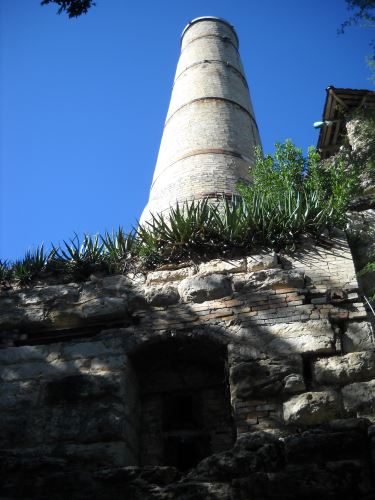
The land which is now Brackenridge Park was also the original headquarters of the Alamo Cement Company (which has had several names, including the Alamo Portland and Roman Cement Company). In 1880, two men, William Lloyd and George Kalteyer, realized that the stone near the river was of a quality suitable for making cement. They founded the Alamo Cement Company and set up operations. Some of the buildings of the company, including the kiln, still stand in the park today. The quarries are now the sites of the Japanese Tea Garden and the San Antonio Zoo.
The smokestack of the kiln of the Alamo Cement factory.
Brackenridge’s original gift to the city was of 199 acres. Brackenridge was fairly progressive for his time, supporting women’s right to vote. Brackenridge did live to see the passage of the Nineteenth Amendment to the United States Constitution, which gave the vote to most American women. There was a hink in that women who married foreign nationals between 1907, when the Expatriation Act, and 1940 lost their citizenship. Some women who married foreign nationals got to retain their citizenship after 1920, when the Cable Act was passed, but the Expatriation Act was not repealed until 1940. There were also practical barriers, such as literacy tests and poll taxes, to voting for immigrant and non-white women in much of the country as late as 1966. But that’s all beyond the scope of this blog post.
Brackenridge was also a prohibitionist. The argument went that alcoholism (and alcohol use in general) was hurting the people of the United States, women and children in particular, and so prohibitionists wanted to make alcohol illegal. And they got their way for 13 years. Prohibition didn’t work out. Illegal production and sale of alcohol flourished which just exacerbated the problems that the prohibitionists had wanted to stop. Additionally, since the sale of alcohol was illegal, it wasn’t taxed, which hurt the economy. Since Brackenridge was a prohibitionist, he forbade the drinking of alcohol in the park. In a twist ending, though, Emma Koehler later donated an additional 144 acres to the park. Koehler’s late husband had been owner of the Pearl Brewery. Since Koehler’s money had come from the sale of alcohol, she allowed consumption of alcohol in her gift. This divide is still present today. In the Brackenridge gift, there is no consumption of alcohol, but it is allowed in the Koehler part of the park.
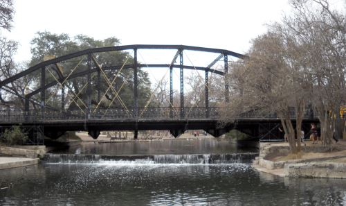
Today, Brackenridge Park holds three pavilions, 1.7 miles of walking trails, the San Antonio Zoo, the Japanese Tea Gardens, sports fields, the Sunken Garden Theatre (an outdoor venue for plays, concerts and other kinds of gatherings), a golf course, and the Witte Museum. The park also has several interesting bridges across the San Antonio River, including a cement bridge carved to look like wood and an iron bridge which was moved to the park from St. Mary’s Street downtown (see image below). I will be doing writeups on the zoo, the tea gardens, and the museum in future South Texas Destinations postings. The Museum Reach portion of the River Walk goes around the golf course and then through the park.
The St. Mary’s Street bridge in Brackenridge Park. I cannot for the life of me remember how I managed to get this angle on the bridge. I think that the river must have bent right there. I do know that I was not standing in the water when I took this.
Most of Brackenridge Park is wheelchair accessible. I’ll try to cover specifics as I write up other parts of the park.
When my now-ex and I were first married, we lived in the northwestern suburbs of Chicago. We used to visit the Chicago Botanic Garden (link to follow after I come back from my August 2016 trip to Chicago) on a fairly regular basis. So when we came down here to Texas and found ourselves with nothing to do one day, we decided to check out the botanic garden here in San Antonio. And, while it was not as elaborate as the one in Chicago (and was much, much smaller!), we liked what we saw. I have maintained a membership to the garden on and off for the last 23 years. I love having a membership because there’s no pressure to spend all day at the garden. If you want to drive on down there and visit the conservatories then leave, you can.
The site that now holds the Botanical Garden was originally the city reservoir. It’s kind of hard to tell unless you’re at the very top of it, but the land is on top of a hill and the city was able to use gravity to deliver the water to homes in the area. This period lasted for about seven years, from 1883 through 1890. According to the Botanical Garden website, local residents began to worry about the reservoir becoming contaminated and so it was abandoned. The land of the reservoir and the surrounding area became the San Antonio Botanical Garden 90 years later, in 1980.
Today, the garden has lots of smaller gardens within it, including a Japanese garden given to the city by our sister city of Kumamoto in Japan; a series of conservatories; an area of small houses that demonstrate different ways to landscape in a water-conscious way without just yanking out your lawn and putting in rocks (a pretty common approach here, I’m afraid); an assortment of formal gardens; and my personal favorite, the “Texas Native Trail.”
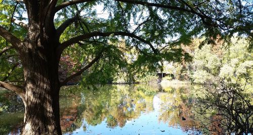
The Texas Native Trail takes up quite a bit of space, so I’m going to focus more on it. There are three sections to the Texas Native Trail. The northernmost part is set up to display the plants of South Texas. The South Texas area has an adobe house from the 1880s. Just south of the South Texas area is an area set up to resemble the Pineywoods of eastern Texas. This section has taller trees than you find in most of San Antonio surrounding a man-made pool. The pool is home to an assortment of animals, including ducks and turtles. The far end of the pond has a reconstructed log cabin first built in Fayette County in the 1850s. The southernmost section of the trail is set up to resemble the Hill Country with prairie plants and a waterfall. The Hill Country section has two historic structures, the Schumacher House, which was built in 1849, and the Auld House, which was built in the 1880s.
The pond in the Pineywoods section of the Texas Native Trail
The garden has a restaurant, housed in the carriage house of Daniel J. Sullivan, an Irish immigrant who set up a bank that helped fund cattle drives. The house, which stood on the land at the corner of 4th Street and Broadway, was razed in 1971. The carriage house stood there for another 17 years. The owner of the land, the Hearst Corporation (who owned the San Antonio Light newspaper) offered the carriage house to the Botanical Garden if they could move it in three months, a task that they (with the aid of the San Antonio Conservation Society) completed successfully. The carriage house is currently the entrance to the Botanical Gardens and I believe that there are offices on the second story.
I say that the carriage house is currently the entrance because the gardens are undergoing an expansion. Much that is currently there will remain, but there is an empty plot of land between Funston and Pinckney streets. The garden owns that land (which has been used for overflow parking in the past) and they are adding new features to it, including a new parking lot and entrance to the gardens. The projected opening for the new section is in the spring of 2017.
The garden has a number of events throughout the year. There are art exhibits and educational programs. They have nighttime events and plants sales, as well. One of my favorite events (and one that I plug to everyone I can) is the Dog Days. For three or four weekends a year, you can bring your dog to the garden for a fee of $5 per dog. That $5 goes to animal-related charities. I try to take my dog (who is a little old lady now) at least once a year because she enjoys getting out and meeting, not the other dogs, but the people at the gardens. And the charities that the garden supports are worth it.
Unfortunately, I don’t think that the garden is as wheelchair accessible as it could be. Some of the paths are steeper than ideal and/or loosely packed sand/gravel/wood chips and, of course, some of the historical buildings are not accessible.
I think I’m done with downtown destinations (though I reserve the right to revisit downtown at any time in the future). I should probably start to write up some of the parks that I’ve visited in the last few years. I guess I’ll start with the park that I visited on Saturday, April 23, Denman Estate Park.
Gilbert M. Denman, Jr. was an attorney and philanthropist who lived in San Antonio. Denman donated many Egyptian, Greek, and Roman artifacts to the San Antonio Museum of Art (review to follow). When Denman died in 2004 at the age of 83, his only heirs were two cousins, and so the executors of his estate broke his real estate into two parcels and sold one to the City of San Antonio and the other (which contained the structures on the property) to the University of the Incarnate Word. The 12.52 acre parcel that belongs to the city has become Denman Estate Park.
When you arrive at Denman Estate Park, the first thing you notice is Denman’s mansion. This is now owned by the University of the Incarnate Word and you can photograph it, but it is private property and there are signs saying that trespassers will be prosecuted.
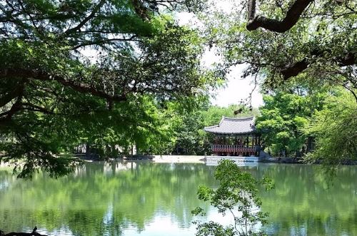
As you travel down the 0.36-mile path, there will be a labyrinth on your right-hand side. I like to walk the labyrinth when I visit. After the labyrinth, the path goes around a pond. On the far side of the pond is a pavilion donated to the park by the city of Gwangju, South Korea. The pavilion was built in Korea and then disassembled, shipped to the United States, and reassembled by the artisans who built the pavilion. There are signs saying that people should stay off of the pavilion. A friend who works in the construction industry says that the pavilion was built with traditional methods. There is not a single nail in the whole thing. This means that it is probably not going to fall down if you go up in it, but it also doesn’t comply with San Antonio municipal building codes and thus is unfit for human occupancy in the city. Also, keeping people out of it will keep it looking as nice as it can for as long as it can. So just admire it from the ground and don’t go up in it.
The Gwangju Pavilion from the far side of the pond, Denman Estate Park, San Antonio, Texas
There is another branch of the path that passes down through a wooded area behind the pavilion. I think I’ve only been down that path once or twice, and it’s a very nice, shady walk.
In front of the house is a statue of a mermaid labeled “AMA MARIA ” and with a set of coordinates. In Spanish, “Ama” is “he, she, or it loves,” so I assumed that the name is in Spanish. It isn’t. The statue is part of a charity art project to raise awareness of the state of the world’s oceans. The explanation for the “AMA” name is that this is the title used for female pearl divers in Japan and Korea. It looks like there are nine of them in existence, and the website tells how to purchase one, if you have €15,000 plus tax (and shipping if you live outside of Europe) burning a hole in your pocket. AMA Maria belongs to the University of the Incarnate Word, but she is on the park side of the house. I’m not sure if she’s on private property or not.
Denman Estate Park is a nice little park to visit if you happen to be in the neighborhood or if you have half an hour or so to spare. The main path is labeled Level 1, so it is wheelchair accessible. The path behind the pavilion is unlabeled, but it seemed to be no higher than Level 2 to me. There are some waterfowl in the park. The Sebastapol geese seem to be the most aggressive of them, and I’ve never had them do more than hiss at me. If you happen to have any ornithophobes in your group, you may want to be cautious on your visit.
HemisFair Park is the site of the 1968 World’s Fair. It has pretty much been a standard park for a long time, a little bit of walking, a playground, buildings to look at, things of that nature.
The 20 houses that were saved from demolition prior to the fair are in the park, and are all currently empty. A number of the other pavilions from the fair are also still there. There is a playground and also part of the Mission Espada Acequia (I’m not sure if I’ve covered the acequias before. They were irrigation ditches that started at the San Antonio River and traveled towards the missions). My now-ex and I, on our first visit to HemisFair Park, got attacked by mosquitoes. We’d been living in San Antonio for a few years by then and had, up until that point, never seen a single mosquito. I guess the relative lack of mosquitoes is something to be said for living in a paved, clear-cut semi-arid place. Probably the only thing to be said for the paving, clear-cutting, and semi-aridness, but it’s something.
There are two water features in HemisFair park as well. We found the first one a few years ago after the Asian New Year Festival when we took a shortcut through HemisFair Park back to our bus stop. The other we just discovered on Christmas Day of 2015. Alex and I went downtown to see the Christmas lights and got there several hours too early. So, we walked down to the Institute of Texan Cultures and then up through HemisFair Park. We took a right turn when we normally make a left and discovered a beautiful fountain with water cascading down a sort of ziggurat-ish structure. We hung around there for a while, taking the path to the top and just enjoying the water.
The top of one of the water features at HemisFair Park, Christmas Day, 2015
The Mexico Pavilion from the fair is one of the only buildings that I can find in the park that’s still open to the public. This building is now the Mexican Cultural Institute (and it is the only national pavilion, aside from the United States Pavilion, that is still in the park). Kitty-corner behind the Mexican Cultural Institute is the San Antonio branch of the Universidad Nacional Autónoma de México (“UNAM”). The San Antonio campus of UNAM is primarily a language school. I considered taking Spanish classes there at one time, but never have had the free time to do so. And if I were to do forward in my Spanish education, I would probably want to get a degree, probably a master’s degree.
There are three buildings left over from the fair which are not part of the park. Two stand on the southern edge of the park, along César E. Chávez Boulevard. One of these two is the John H. Wood Jr. Federal Courthouse, which originally was the Confluence Theater of the United States pavilion of the fair. The other is now the Institute of Texan Cultures (“ITC”), which originally was the State of Texas Pavilion. The third building is the Henry B. González Convention Center. Both the courthouse and the convention center have fallen into disrepair, which leads me to what is likely to be my final point with regard to the park.
Much of this information is soon to be out-of-date. The city is currently overhauling the park. There is a new convention center which, I think, is now complete. Soon the will raze the old convention center. The city also has $135 million earmarked for a new courthouse. They will overhaul most of the park, as well. The plan is to put an apartment building in the park and there will be some retail businesses added. I read something just today about the city wanting to put restaurants and other businesses in the empty houses in the park, and part of the population of the city is agitating to remove the ITC building and move the museum to a new location more central in the park. The University of Texas at San Antonio, which owns the ITC, is resisting any such changes.
The ITC is surrounded by a metal fence. I would like to see that fence done away with. One of the big arguments of those who want to see the museum razed is that it doesn’t feel like part of the park. Removing that damned fence would go a long way towards making the museum feel like part of the park (the other would be removing the parking lot, but in a car-centric city like San Antonio, I don’t think that will happen). I believe that the ITC is one of only three museums that I’ve been to that have fences around them. One other is the McNay Art Museum, which used to be a private home in a not-very-pedestrian-friendly area, and the other is the Vatican Museums in Italy, and it would be weird to take down the centuries-old wall there to make the museums more accessible. I’ve been to a lot of museums mostly, but not necessarily all, in Chicago, New York City, San Antonio, and the District of Columbia. I’ve even been to the Reading Museum (because I wasn’t about to miss a chance to see England’s copy of the Bayeux Tapestry). And people can just walk up to just about all of the ones I can think of. Maybe I should have left this to my post on the ITC, which is scheduled for April 15, more or less, but I’m on a roll now, so I’ll just leave it.
This will probably end up being a Part 1. Part 2 will follow in another two years or so, once they have the official opening of the renovated park.
Okay, do I start with Benjamin Milam or with the cemetery? :flips coin:
I literally did just flip a coin there, and it came up tails, so the cemetery it is.
In the 1850s, there were two graveyards in the area near the intersection of Houston and Santa Rosa Streets. On one side of the line which is now Houston Street (underneath where the Children’s Hospital of San Antonio is today) was the Catholic cemetery. On the other side of that line was a public cemetery for non-Catholic burials.
After only a few years, the number of dead in the public cemetery became too great for the small plot of land and all of the bodies there, except, to our knowledge, one, were moved to other cemeteries. That one body belonged to Ben Milam.
Benjamin Rush (Ben) Milam was born in 1788. In the early 1800s he moved to Texas and when the war for Texas Independence began, he is claimed to have called for recruits to take the town of San Antonio by calling out “Who will go with old Ben Milam into San Antonio?” In one version of the tale, he is said to have drawn a line in the dirt on the ground with a stick in his hand. This will be important later.
Milam was killed during the Siege of San Antonio by a gunshot to the head. He was on his way to the “Veremendi Palace, which the house gained the title “Palace” because it had been home to one of the governors of Coahuila y Tejas. The Veremendi Palace was on Soledad Street not too far from Main Plaza. Milam’s body was buried in the yard of the house originally and later his body was exhumed and moved to the public cemetery.
Once his body was interred in the public cemetery, a marble marker was placed over the spot. Later that marker was removed and replaced by a granite monument, which was originally supposed to have been surmounted by a statue. They never put the statue on the monument. 34 years after Milam’s burial, they turned the land into a park and named the park for Milam. In 1938, the Texas Centennial Commission put a statue of Ben Milam holding a rifle aloft in his right hand on the west edge of the park. Over the intervening decades, the knowledge that the granite monument was a gravestone was lost and, in 1976, the marker was moved as part of a park beautification project.
The statue of Ben Milam in Milam Park, San Antonio, Texas
In 1993, the city began renovations on the park and the workers found a skeleton under a concrete slab. The slab was near the center of the park and was just little larger than the size of the granite monument. Since the granite monument was heavy and had originally been planned to be even heavier, the archaeologists who were monitoring the project decided that the concrete slab may have been the original foundation for the granite monument. If that were true, the skeleton had a good chance of being Milam’s remains. They exhumed the body and took it to the Center for Archaeological Research at the University of Texas at San Antonio.
The remains were of a man of about Milam’s height who was about Milam’s age at death. Only fragments of skull were found, but they had markings consistent with having been killed by a gunshot to the head. Remember the stick in Milam’s hand up there? In that tale, he didn’t pick it up from anywhere, it just sort of was in his hand. The body was found to have belonged to someone with arthritis in his legs and back, and, well, a cane is, in fact, a stick that you hold in your hand.
Remember that that land was only a cemetery for a few years. The odds of another body having been placed beneath a concrete slab the size of the grave marker for Milam during those few years are slim. Add to that the fact that the body found was a male the same height as Milam makes the chance that it’s anyone else slimmer. That plot of land was a cemetery decades before the era of the old west gunfight (and San Antonio hasn’t been so much “western United States” as “northern Mexico”). Most of the bodies in the cemetery had died of things like cholera and old age. As a result, the bullet wound to the head makes it nearly certain that the skeleton belongs to Milam.
The body was re-interred under the statue in Milam Park in 1994.
Milam Park is a nice little (emphasis on “little”) park. From what I can tell, it is around four acres in area and, in addition to Milam’s grave, has a playground, a gazebo, picnic tables, and a quarter of a mile of walking trails. As with most other urban parks, Milam Park looks pretty wheelchair accessible. The park is all level and paved and there are curb cuts.
The area where La Villita Historic Arts Village (“La Villita”) stands today has been occupied by humans for centuries. Prior to the arrival of the Spaniards, that are on the shore of the San Antonio River had been home to a community of Coahuiltecan Native Americans. Around 1722, the soldiers from the Presidio (the Presidio was where Military Plaza and the San Antonio City Hall are today) lived in huts on that site with their families. That community was later destroyed by a flood.
Then, in the early 19th Century, a group of immigrants from Germany built more permanent structures on the site. The Germans were followed by immigrants from Switzerland, France, and Italy. These are the buildings that are there today. As with so much of the historical sites of San Antonio, the buildings of La Villita fell into disrepair. During the Great Depression, the buildings were restored to their original condition, and La Villita began its current life as an arts center.
Today, La Villita is home to shops, galleries, and restaurants. Several festivals are held there, including the Fiesta event, A Night in Old San Antonio (popularly called by the acronym “NIOSA”). My family and I also attended the India Association of San Antonio’s annual Festival of India at La Villita in the early 2000s. Even though this information will be outdated in a couple of months, the 2016 festival will be held on March 26. I do not know if it will be held in La Villita again, though.
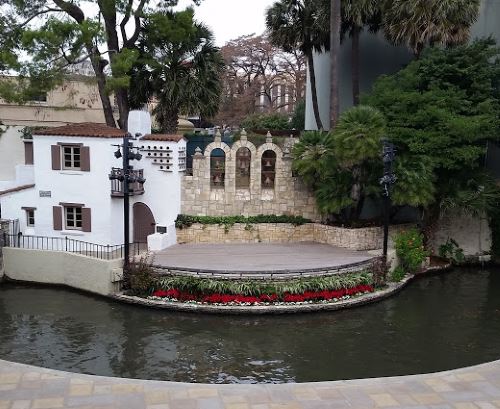
The Arneson River Theatre abuts La Villita on the San Antonio River side. The theater is set up in an unusual but picturesque way, with the audience seating on the La Villita side and the stage on the other side of the river.
The stage of the Arneson River Theatre, San Antonio, Texas
The streets of La Villita are level, but not all of the shops are wheelchair accessible. The Arneson River Theatre has steps leading down to (or up from, depending on your perspective) the river, but I am pretty sure that there is wheelchair accessible seating at street level.
San Pedro Springs Park which has also been known as just “San Pedro Park” in the past, is (depending on how you count) the second-oldest public park in the United States. The land where San Pedro Springs Park currently is was set aside for public use by the King of Spain in 1729, making it 95 years younger than the oldest public park in the United States, Boston Common. The “depending on how you count” is because the Trust for Public Land, which apparently uses different criteria for “park” places San Pedro Springs Park at tenth-oldest. Either way, though, San Pedro Springs Park is one of the oldest parks in the country.
Humans have been living in and around the area that is now San Pedro Springs Park for millennia. When the Spaniards arrived in 1709, the area was home to a Coahuiltecan tribe known as the Payaya. The Spaniards knew a good thing when they saw it, so they decided to move in there, as well. Unfortunately, there were two groups of Spaniards — soldiers and Franciscan missionaries and there was apparently some kind of conflict between them. Eventually, the missionaries set up on one side of the river and the soldiers on the other. This is the first of the missions named for San Antonio de Padua (the final one of these is the Alamo). The mission was moved to the other side of the river, then to where St. Joseph’s Church is today (I must remember the link when I get to writing up St. Joseph’s), and then to its final location.
In what is likely to be the most confusing sentence I will ever write, parks today aren’t what they were then. Parks started out as land for sort of general public use. Boston Common, the oldest park in the United States, was originally a field where residents could graze their cattle. And so it was with San Pedro Springs Park. The original use was primarily for travelers, however. The travelers would let their animals eat and drink and refill their water containers in this area. It wouldn’t become a park as we recognize the term until 1864.
Prior to 1864, one tenant of the land that is now San Pedro Springs Park was the military. Because of this history, the stone house in the park is generally thought of as an old fort or possibly a storage building for weapons. No one is sure where the building, generally known as the “Block House” was built, but a 1909 photograph shows a building that was already apparently old, and the architectural style looks to be from the mid-1800s.
Among the uses that we are sure the military put the land to was the garrisoning of soldiers and stabling camels that the Army attempted to use in military campaigns. The park was also a prisoner-of-war camp during the Civil War.
In 1864, a man named Jacob Duerler took over the park. He got a license to use the park for 20 years in exchange for fixing the damage done by the soldiers (and the camels) during the years when the military used the park. Duerler opened up a number of amusements including a fish pond and a bar. Duerler died 10 years into the 20-year period, and eventually his son-in-law took over. His son-in-law mismanaged the property and so when he wanted to break the lease early, the city allowed it. A new tenant, Frederick Kerbel, took over and made still more improvements to the park, including landscaping and the addition of a “grotto,” generally thought to be a summer home, which stands there today, and which looks kind of like a very large statue of Cousin Itt from The Addams Family.
When Kerbel’s lease expired, the city took over management of the park. Some of the buildings built during the era when the park was let to tenants remained, including the grotto and a strange star-shaped structure that originally had a fountain in the center.
When I first moved to San Antonio, the park had not been renovated for a long time and it looked sort of post-apocalyptic. They have done quite a lot of renovation, including upgrades to the swimming pool and the addition of a small skateboarding park. The park has a lot more visitors these days than I saw in my first visits, which is lovely to see.
Since San Pedro Springs Park is a historic landmark, there are some places that are not handicap accessible. For example, the photo at the top of the page was taken at the top of a flight of stairs. The top of that sort of bluff thing is accessible by a sloped path, however. The “shallow end” of the pool actually is a ramp that leads into the pool, making the pool itself handicap accessible (though I’m not sure about taking one’s wheelchair into the pool itself), from what I have read.