2016 Vacation: Yellowstone National Park, Part 2

Look it’s September 3 and we’re back. I probably shouldn’t be as surprised by that as I am, but it is nice when my schedule works out as planned.

We got out a little earlier on our second day in Yellowstone, but not as much earlier as I would have liked. We actually bought breakfast in the hotel for once, so that used up some time, and then we went to the supermarket in West Yellowstone, which was *not* like the supermarkets back home. The produce section was very small and most of the store was prepackaged food. We generally like to get our pop from a supermarket rather than convenience stores, because we can get six bottles for the price of two or three from a convenience store. I’m never going to be able to retire on those savings, but it helps. The supermarket we visited didn’t even have six-packs of pop, just the same individual bottles you get at the convenience store. So that used up some time.

Then we hit the traffic. It was a Saturday, so Yellowstone was more crowded than it had been on Friday, but the biggest problem was road construction. It’s winter for quite a long time every year at that elevation, so tourist season is also construction season.  And while we were there they were fixing the Grand Loop Road leading to Old Faithful. We wanted to get to Lake Yellowstone anyhow, so I suggested that we go around the long way, past the lake, and back to Old Faithful. We realized that would be at least a two-hour drive, so we opted to try our luck with Grand Loop Road. I have basically no sense of time, so I don’t actually remember how long we sat there; it certainly seemed to be longer than the half hour they expected it to be.

I had also just recently read that National Geographic article on Denali where we find out that there is a big parking lot by the visitors’ center and that everyone who goes into the park takes a bus. Visitors can get off the bus pretty much anywhere and then get back on the bus pretty much anywhere as well. I sat there in traffic wondering aloud just what it would take to implement a similar program at Yellowstone.*

Finally we made it to Old Faithful and, in contrast to the previous night, we had trouble finding a parking place. Our rental car was white, as were a lot of the other cars in the lot, which made it more fun to find the car in the lot on our way out.

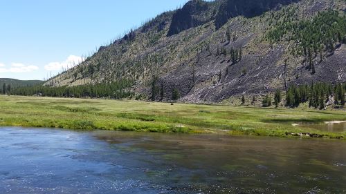
We got there so late that we wrapped around to being really early, so we ended up with time to kill. We bought some souvenirs and a couple of soft pretzels in the Old Faithful Lodge while we waited. Then when we went back outside the only benches available were way off to one side, so we sat on the boardwalk itself, which ended up being a nice place to sit, because it gave me a nice angle on the grasses in front of the geyser as they waved the breeze.

Old Faithful, 2016
Old Faithful, 2016

A helicopter landed out behind the Old Faithful Inn while we waited for the eruption, and Alex loves vehicles of all types, so we went in search of the helicopter. It was a nice walk, and Myriad Creek, which runs behind the Inn, is very pretty, but we could have just followed the signs to the medical clinic, because that’s where we found the helicopter.

After that we went into the Visitor’s Center because I promised myself that I would go into the backcountry at least once, but I’m also not an idiot. I know that people can get hurt or killed if they exceed their hiking abilities. So I asked the park ranger there what he would recommend for a “baby” hiker. He recommended a fairly easy path that would take us two hours to complete. We ended up walking 45 minutes or so, out and back. We did head into the woods briefly just to do it, but I put hiking mode on my phone so that we wouldn’t get lost; we were able to just follow the path that we’d walked out back (take that, Hansel and Gretel!).

Back to Old Faithful, though. We considered having ice cream at the Old Faithful Inn before heading back out, but the lines were tremendously long and we figured that we could get ice cream at Lake Yellowstone (spoiler alert: we were never able to find it). So we headed out.

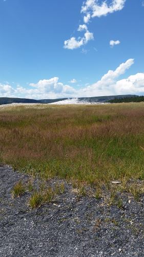
We stopped at Isa Lake, which sits right on the Continental Divide and is notable for being the only known natural lake that drains into both the Atlantic and Pacific Oceans. Then we made it to Lake Yellowstone, which is not the easiest place to find parking, believe me.  The parking lot for the hotel was full, as was the parking lot in front of the hotel, and there was exactly one spot available in the parking lot for Lake Lodge. Since we didn’t find ice cream there, we chose to go somewhere we were certain would have ice cream — the Canyon Village Deli, where we’d had sandwiches the previous day. So we headed back up towards Canyon Village and got ice cream. I tried the huckleberry flavor, which was pretty good, but after all of that driving, I needed chocolate. So Alex and I both got cups of Moose Tracks and mint chocolate chip. And, as with the previous day, the people there were great.

We would have liked to have spent more time at Yellowstone, but I wanted to make an early night of it so that we could head out for Vernal Utah early the next morning. We didn’t make it out (of the park or of our hotel) as early as I would have liked.  You see, on our way out, we finally had our first wildlife-induced traffic jam. We’d had gapers’ blocks from wildlife alongside the road (a black bear, a grizzly bear, a bull elk, etc.), but on our way out, we actually ended up behind a bison. Alex attempted to take a picture, but the bison was near the center line on the road so he couldn’t get it for me. As luck would have it, the car in front of us came to a complete stop at one point, giving me a chance to stop completely and put my car in park long enough to snap a quick picture.

It was nearly dark by the time we made it back to the hotel, so we went right to bed and, the next morning, headed for Vernal Utah.  We’ll return for that drive on or around September 11.

*I did some research later and by my calculations, you would need a 2700-car parking garage just outside each entrance, which would be about half the size of the parking garage at the San Antonio International Airport. You could drop San Antonio into Yellowstone and still have space around the city, so if you can drive past the airport parking garage and not notice it (which you can), it should be possible to build those five garages without too much disruption. Alex objected, saying that most people would probably want their cars.  So I figure that you let the most motivated drivers bring their cars.  Let a couple of hundred cars in at each entrance (for an extra fee) every day. This would reduce the size of the garage that you would need to maybe 2500 cars. Of course, RVs that are headed towards the campgrounds would always be allowed in, so long as they go pretty much right to their camping spot.

2016 Vacation: Yellowstone National Park, Part 1

I don’t know how long my discussion of Yellowstone will turn out to be, so I’ve tentatively labeled this as Part 1.

Alex and I got kind of a late start on our first day at Yellowstone. The drive from Salt Lake City had taken a lot longer than we had expected. In addition to the two hours of scheduled stops, and the unscheduled more than an hour Rocket Display stop, I forgot my rescue inhaler, so we had to transfer it to a Walmart in Idaho and wait for it to become ready. I estimate that rather than taking four or five hours, it took eight or nine. At this point, I was not in a rush to get back in the car, even though I thought that I’d get plenty of time out of the car at Yellowstone.

I didn’t get lots of time out of the car at Yellowstone. Let’s put it this way. San Antonio is the 67th largest city in the world in terms of land area. You could drop San Antonio on top of Yellowstone (not that I’d recommend this) and still have lots of space around the edges (19 miles all the way around, if my math is correct). So, yeah. Unless you book a bus tour, expect to spend lots of time in the car.

Overall, I have to give Yellowstone a solid four out of five stars for producing megafauna to gawk at. Minutes after entering the park, we saw our first bison. By the time we left Yellowstone heading for Dinosaur National Monument, we saw even more bison (including several herd of bison in the distance, one ahead of us blocking traffic, and one alongside the road so close to our car we could hear it breathing — that was unnerving), a black bear (which was too close to the road, but we stopped and took a couple of pictures anyway, a grizzly bear (likewise), at least one yellow-bellied marmot, and at least one elk (or maybe one elk and two moose cows, or possibly two elk and one moose cow). I think I saw some pronghorn antelope in the distance once. We also heard something howling on two separate occasions (I’m not sure if they were coyotes or wolves). No dall sheep or actual sightings of wolves, and also it would have been nice to have gotten a picture of the things that I thought might be pronghorn.  If I’d gotten those squares on my megafauna bingo card, Yellowstone would have rated five out of five.

Yellowstone Madison River Bison 2016
Believe it or not, that brown lump pretty much right in the center of the image is a bison. I also have some closer photos of it, but I wanted to share just the tiniest bit of the scale of the park as well. The water in the foreground is the Madison River.

We chose not to go to Old Faithful first because Alex wanted to do some stargazing and I read several things that said that the area around Old Faithful is a good place to stargaze, largely because there are people there pretty much around the clock. Since it was just the two of us, I figured that keeping to populated areas after dark would be a good plan. As it turned out, 81% of the moon’s disk was visible that night, so the light pollution from the moon ended up causing us difficulty with the stargazing. I still owe Alex a stargazing trip.

Back to that morning. We’d heard that there had been snow at the higher elevations in Yellowstone, so since we started out kind of hungry, we chose to eat at the Canyon Village, which is the highest in elevation (I hoped that perhaps Canyon Village would be close enough to the highest elevations that we could see if there actually was snow up there and maybe find a route up to it). We ended up eating sandwiches at the deli and while they were, you know, sandwiches, and not terribly exciting as cuisine goes, the people there were very pleasant and helpful. This set a very nice tone for the day.

After we ate, we stumbled across the Grand Canyon of the Yellowstone, which is a place where the Yellowstone River cut into the rock and, well, created a canyon (just like it says on the tin). We found, and spent entirely too much time photographing, the Lower Falls. We saw a boardwalk that led down towards the river and, because I’m too adventurous for my own good sometimes, I convinced Alex to go down there with me. The trip down was great, but the trip back up was a bit strenuous. Just a year ago, he and I had climbed the Statue of Liberty with no problem, so I was sort of distressed about just how difficult I found the walk back up. However, the elevation of the Grand Canyon of the Yellowstone is around 6,000 feet, so perhaps that made at least some of the difference.

After this, we went in search of even higher elevations, which led us up into the northwest corner of the park. I didn’t want to attempt to climb Mount Washburn. Oh, who am I kidding? I probably would have totally been up for it (despite the adventure I had coming back up at the Grand Canyon). Alex talked me out of it. Mount Washburn was probably our best shot at seeing snow on this trip, too. Oh, well, maybe it’ll snow in Dallas this year and we’ll luck out and be able to go up to Dallas to see it.

While we were in that corner, we drove into Fort Yellowstone, where we saw an animal that I at first identified as a horse. Alex was taking pictures of it, and I asked him why he was taking pictures of “that horse.” He told me that it clearly was not a horse and later, when I looked at the pictures, I think it might have been a moose, though it was more of a yellow color than I was expecting. Looking at other pictures of moose and elk, maybe it was an elk.

We parked and kind of knocked around a while at the Mammoth Hot Springs area (and I would like to go back and stay at the Mammoth Hot Springs Hotel some fall or winter) and took a lot of pictures of the thermal features there.

At this point, it was getting pretty late and we were looking at an hour and a half drive, so we headed towards Old Faithful. We took even longer than that, because we found a whole area of thermal features that needed to be explored and photographed.

Finally, with the sun beginning to sink in the west, we headed for Old Faithful. We got there just after an eruption, so we had an hour or so to kill, and during that time, the sun went down almost completely. I took some photographs of the geyser before the sun went down and then again afterwards (I also videoed the eruption, but my phone camera is not fantastic at night photography, so the video is mostly whooshing noises and blackness). We stuck our heads into the Old Faithful Inn (I had wanted to visit the Inn because I remember the 1988 wildfires that came *this* close to threatening the Inn). We then went to the Old Faithful Lodge and got a drink and two huge cookies to eat while we waited.

One of the nice things about watching Old Faithful erupt after nightfall is that almost no one is there. We had fantastic seats. And the geyser gave us a nice several-minute show. After the eruption we looked at the stars for a bit, but I wasn’t sure if they really would let us out of the park that late at night, and we still faced a 45-minute drive (during daylight hours — we were driving just a little more slowly because I didn’t want to end up wrapping the car around a moose or something) back to West Yellowstone, so we headed back out. We stopped along the way and looked at the stars again on the way, as well.

And, since we’re at over 1,000 words, this looks like a good place to stop for now. So I will end up with at least two posts on Yellowstone. We’ll meet here in Montana/Wyoming again on September 3, I think?

I’m Back from Vacation

And I only cracked a National Geographic open once.  I’d better get going on that.

It was a great trip, even if I did end up spending quite a lot of it behind the wheel of a car.  I’m not a huge fan of driving, but I figured I could handle a couple of days of long-haul driving. I totally underestimated the size of Yellowstone. You could drop San Antonio in the middle of the park and there’d still be about 19 miles in every direction left over. So, yeah.  I spent a *lot* of time behind the wheel of the car.

I did take nearly 700 pictures, though. Well, since I was driving for quite a lot of the time, Alex took probably one in five as my agent. I’d say, “Ooh! That’s pretty/interesting/whatever! Get a picture of that!” and he’d pick up my phone and snap at least one picture, sometimes several, to get the subject from different angles as we drove.

I’m supposed to have a new post out tomorrow, and since I’m behind on the National Geographic reading, I guess that I’ll probably write about Temple Square in Salt Lake City, since that was our first destination on the trip.  Well, it was our second, but the first was the Family History Library and while I think I may have found an ancestor’s birth records I can’t be sure that I did, so I’ll probably mention it in passing, rather than dedicating a whole post to it.

Or should I talk about playing Pokemon Go? Since I love to see new things and really love walking, I figured that Pokemon Go would be a good thing to try, and so I tried it on this trip. I should have been asleep half an hour ago now, so it doesn’t matter which I will do, I’m certainly not going to get it done now.

National Geographic March 2016, Part 2

This post should launch on the day when I’ve been telling my friends and co-workers that I’m going to be eaten by a grizzly bear. Alex and I will be on our first day of two in Yellowstone on Friday, July 15 (Leap Year is so weird; last year, Friday was July 17 so the corresponding Friday this year should be the 16th, but because of Leap Year, it becomes the 15th). We fully intend to leave the path and go at least 100 yards into the backcountry. The official statistics say that something like 5% go farther than 100 yards from a paved path. So, since I like to live on the edge, I fully intend to go at least 101 yards from a paved path.

However, I’m not an idiot. At least, I hope I’m not. We’ll have fruit and water and probably something salty (because passing out from hyponatremia’s not my idea of a good time) with us and I fully intend to tell the park rangers that we’re relative newbies and ask where is a prudent place to experiment with the backcountry.  I won’t have a keyboard with me, so I won’t be writing any new posts until I get back. You’ll know on or around July 21 where we ended up going.

Now, on to the issue:

The Other Iraq, by Neil Shea, photographs by Yuri Kozryev

In 1970, Iraqi Kurdistan achieved an autonomous status within Iraq. Iraqi Kurds had their own capital, Hewler/Erbil (depending on if the language is Kurdish or Arabic), their own President and Prime Minister (I’m not entirely sure how that works in practice), even their own army (the Peshmerga).

Since the deposition of Saddam Hussein in 2003, Iraqi Kurdistan has had a sort of Renaissance. The Kurds sold the oil under their land and used the money to build universities, to establish a health care system, and to upgrade their cities with malls and skyscrapers.

In The Other Iraq, Shea follows two Iraqi men, Kurdish Botan Sharbarzheri, who dropped out of school to join the Peshmerga, and Arabic Sami Hussein, who joined ISIS. Through the tales of these men, we see how Iraqi Kurdistan has suffered from the forces of ISIS.

By Shea’s final visit to Iraqi Kurdistan, Sharbarzheri has returned to school to study international relations and Hussein has most likely been executed. The of Iraqi Kurdistan is a shadow of its former self, with much of its population gone to join family in other parts of the world or just become straight-out refugees.

Tsunami Memories, by Jeremy Berlin, photographs by Alejandro Chaskielberg

Tsunami Memories discusses Chaskielberg’s photographs of the people of Otsuchi, Japan, a town that was destroyed by the 2011 tsunami. Inspired by faded photographs that Chaskielberg saw in a waterlogged photo album, Chaskielberg took black-and-white photographs of the residents of Otsuchi in the places where they lived, worked, or played.  He took his photos at night with a long exposure so that the images turn out slightly blurred and then added colors on his computer using a palette based on the colors in the damaged photo album.

National Geographic January 2016, Part 1

So far, this issue is going much better than the previous one. Let’s see if I can keep up this momentum.

A couple of times in my life I have traveled somewhere just in time for something interesting to happen.  The most notable of these was my family’s trip to the UK.  I had breast cancer in 2001 (it’ll be 15 years this October and I haven’t seen any sign of it since then, so I’m pretty sure I’ll be okay at this point) and decided that I wasn’t going to die without ever having been to the UK, so we made our plans.  As we finished the plans, we realized that we’d be there just in time for the Queen’s Golden Jubliee celebrations.  We also were in London on June 7, which was the day of the World Cup match between England and Argentina, a match that England was apparently expected to lose, but which it won.

How does this tie into my National Geographic project?  For 2016, National Geographic is doing a series on the National Park Service in honor of the Park Service’s centennial.  I didn’t even know that 2016 was going to be the centennial for the National Park Service when I planned a three-national-parks-and-a-national-forest trip which includes the oldest National Park, Yellowstone.  This was a complete coincidence.

How National Parks Tell Our Story — And Show Who We Are, by David Quammen, photographs by Stephen Wilkes.

Just like it says on the label, this article goes into the history of the National Park Service and tells how they decided on a single vision for national parks.  The photographs in this one are awesome, even for National Geographic photos.  Wilkes set his camera up at an elevation and took thousands of pictures of parks (Yosemite, Yellowstone, the Grand Canyon, and West Potomac Park) over one day.  Then he pasted them together into panoramas showing the vantage point through the night and the daytime.

This Is Your Brain on Nature, by Florence Williams, photographs by Lucas Foglia

This is Your Brain on Nature is about the health benefits of getting out and getting some “green time.”  Williams even goes so far as to say that people may have lower incidences of physical ailments if they live within half a mile of green space.  On the other hand, there is the “urban advantage,” where people who live in cities tend to have have longer, healthier lives than those in rural or suburban areas.  Some of the “urban advantage” probably comes from access to health care, and others come from being able to walk to destinations rather than having to travel in a car to get there.  I wonder, too, if the presence of urban parks makes a difference.

Our Big 2016 Vacation is Now Booked

And tomorrow the credit card payment should clear and I can pay it off.

In 2016, Alex and I will be adding five new states to our collection:  Utah, Idaho, Montana, Wyoming, and Colorado.  Not that we’ll be doing any of them in too much detail. We’ll be traveling to Pando (never pass up the opportunity to visit the world’s most massive single organism (as opposed to the largest, which is a fungus in Oregon)), Salt Lake City, Golden Spike National Historic Site, Yellowstone National Park, and Dinosaur National Monument.

I’ll be getting my city fix in August when Alex and I are planning a four-day trip to Chicago. Hopefully I’ll be able to take some pictures to spruce up my Northern Illinois Destinations posts while there.